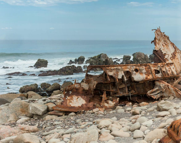
| Name | Date/place | Available information | Photo |
|
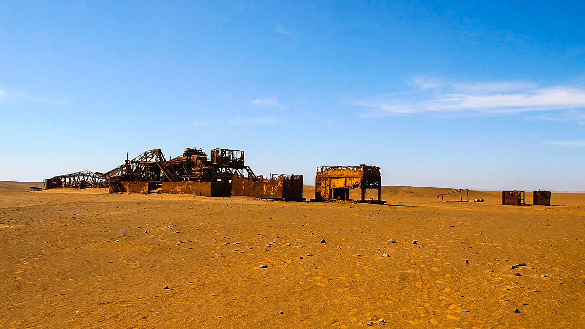
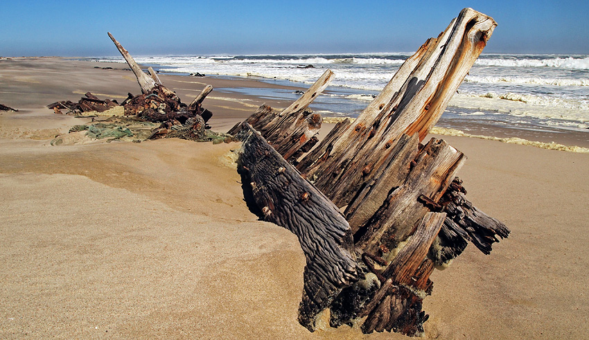
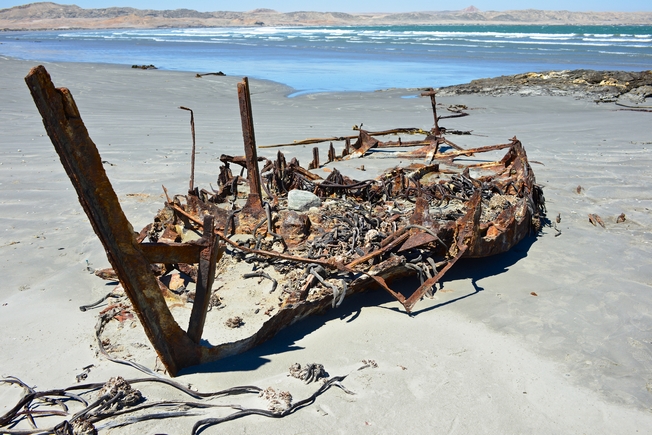
1. Abandoned oil rig |
Skeleton Coast, near Toscanini -20.890122, 13.447250 |
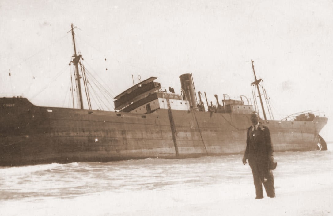
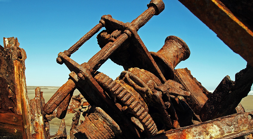
Cease of operations date is not known. An abandoned rusted oil drilling rig, located near Toscanini, was operational in the late 60's and early 70's. Rig is equipped with main power unit, V16 Caterpillar engine and was installed by brave local entrepreneurs long before the Skeleton Coast National Park was proclaimed. Today, rusty structure provides a nesting area for birds during breeding season. |
|
| - | - | - | - |
|
1.1. "Achillet" |
1971/ Walvis Bay |
This motor powered freighter wrecked at sea north-west of Walvis Bay. | - |
| - | - | - | - |
|
1.2. "Acme" |
1893 July/ Kunene River |
The steamship grounded near the Kunene River Mouth. Another source give location as Kaiserin Auguste Bucht. | - |
| - | - | - | - |
| 2.0. American Whaler |
1800ĺs/ Omaruru River mouth |
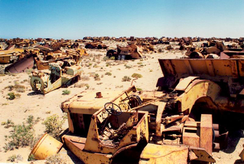
Some old sail ship ribs and beams were visible above the high
water mark at the Omaruru River mouth. Visitors like Hentie van der
Merwe and Sergeant Ross of the Omaruru police used to cut their bait on
one of the large beams. In later years some of these wooden sail ship
beams might have been used as building material for some of the first
holiday houses erected at
Henties Bay, or carried away by one of the
salt companies who operated further north. Excerpt from Dr. Vedder "Das alte Sudwestafrika", 1981 book: ôHerero chief Hembapu returned along the coast towards the Omaruru River after a raid on some Nama further south. At the river mouth they came upon a shipwreck and two naked white men ľ white people they had never seen before. They gave them Omaire. The one man died shortly afterwards. They slaughtered an ox in order to leave some meat for the other survivor. The Hereros then commenced trekking further inland along the Omaruru River.ö Unfortunately, no date of that particular incident is known. |
- |
| - | - | - | - |
|
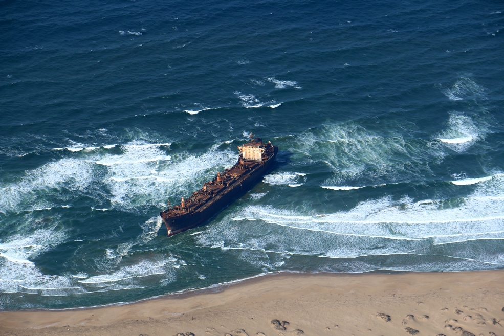
2.1. "Annebelle" |
01.08.1969/ Vineta, Swakopmund |
- | - |
| - | - | - | - |
|
2.2. "Anita I" |
1954 | Pelican Point | - |
| - | - | - | - |
| 2.3. "Anita II" |
1968/ Henties Bay |
This fishing vessel foundered in Henties Bay. | - |
| - | - | - | - |
| 2.4. "Ann" |
08.01.1845 | Ambrose Bay | - |
| - | - | - | - |
| 3. "Anne Mondell" |
1840s/ Ichaboe Island |
- | - |
| - | - | - | - |
| 4. "Arkona" |
Namib-Naukluft Park, north of Spencer Bay | Remains of wreck of "Arkona" is located a couple of kilometres north of the "Otavi" wreck. It is hardly visible. |
 |
| - | - | - | - |
|
5. "Atlantic Harvester" |
27.05.1967/ Mercury Island |
- | - |
| - | - | - | - |
|
6.1 "Atlantic" |
1977 | 20 miles north of Torra Bay. | - |
| - | - | - | - |
|
6.2. "Atlantic Pride" |
07.03.1972/ Between Huab and Koichab Rivers |
|
- |
| - | - | - | - |
|
7. "Auckland" |
20.02.1909/ Possession Island |
- | - |
| - | - | - | - |
|
8.0 "Balgowan Castle" |
August 1904/ Easter Cliffs |
The route to the wreck leads over the cliffs past huge whale bones scattered on the
desolated beach. It travels all the way to Easter Point, where diamond mining took
place in 1924. An old truck with wooden spoke-wheels near an old shack
can be viewed as well as the remains of steamship ôBalgowan Castleö,
which ran aground in 1904. Twelve miles to the south of Sylvia Hill
are Easter Cliffs, high and rugged, with a hull of the steamer Balgowan
Castle still gripped firmly by the rocks at the base. She carried many
cases of candles in her cargo, and for years prospectors supplied
themselves with |
- |
| - | - | - | - |
|
8.1 "Bali" |
24.12.1910/ Penguin Island Luderitz |
- | - |
| - | - | - | - |
|
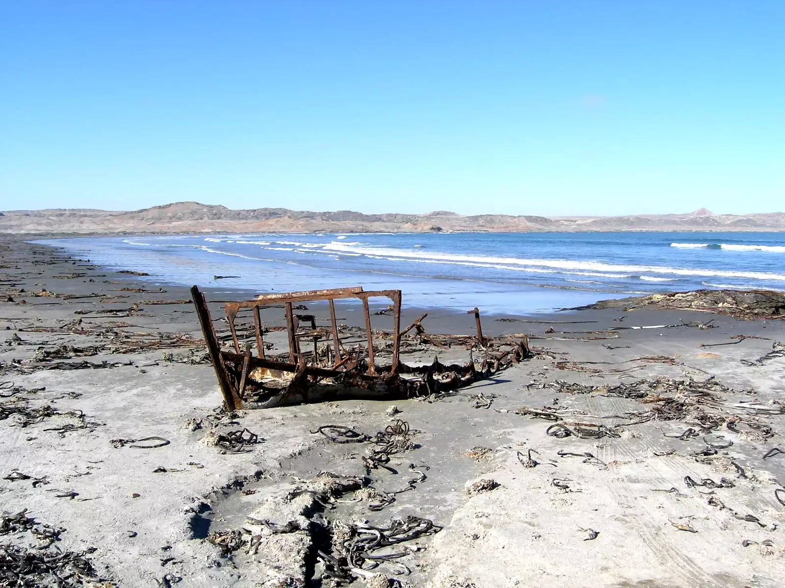
9.0. "Benguela Eagle" |
05.06.1973/ 25 km north of Ugab River |
The shipwreck is located 25 km north of the Ugab River, inside the Skeleton Coast National Park. Benguela Eagle was a 78 ton fishing vessel that ran aground on 05 June 1973. According to another source of information Benguela Eagle fishing vessel was wrecked between the Uarib and Hoanib rivers in 1968 and not in 1973. |
|
| - | - | - | - |
|
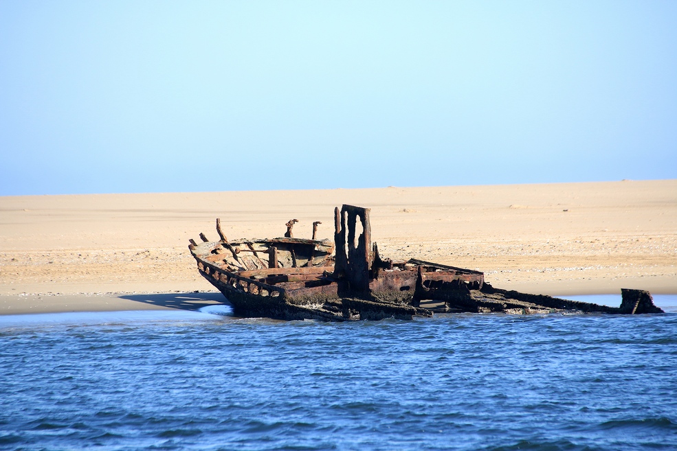
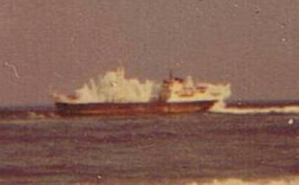
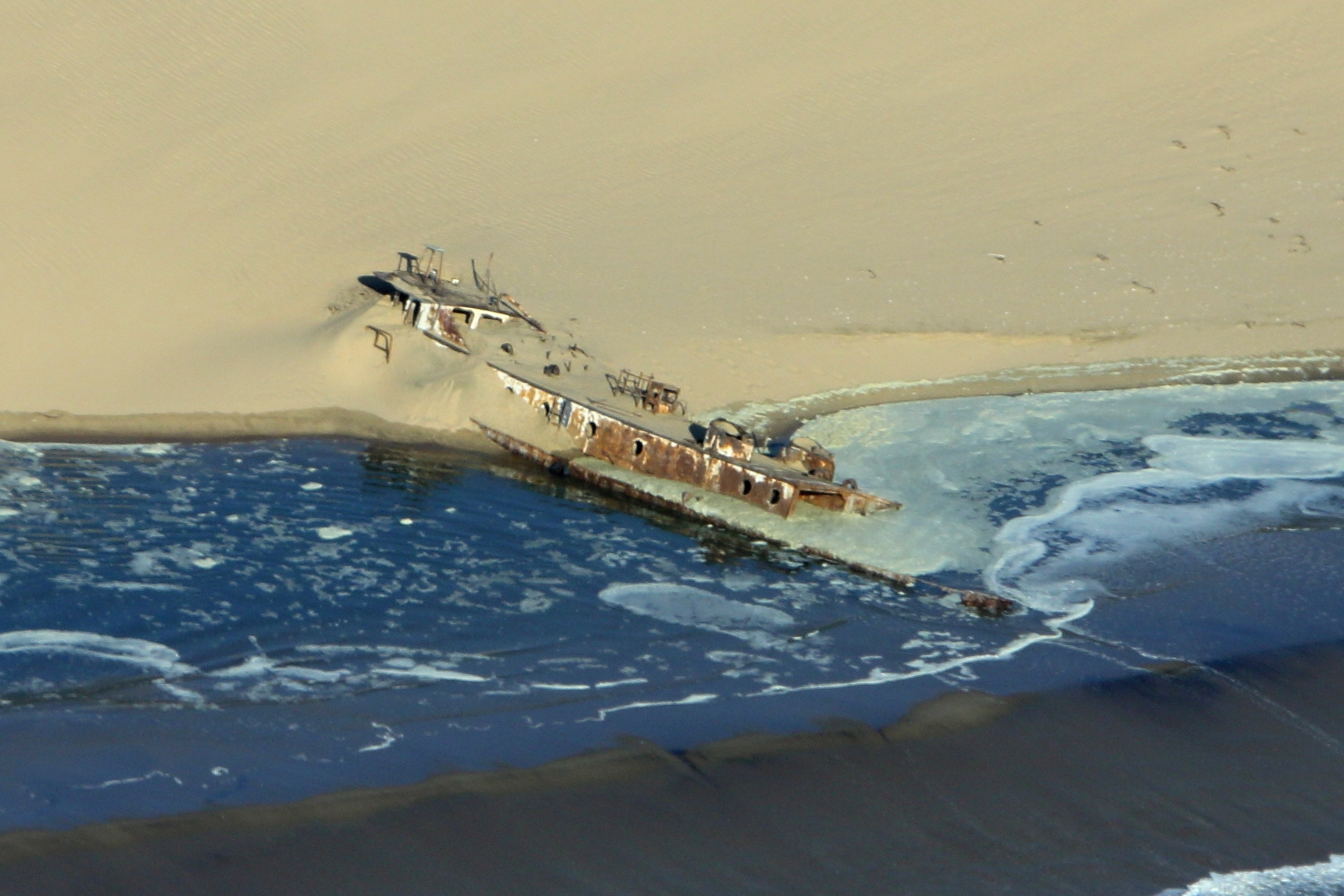
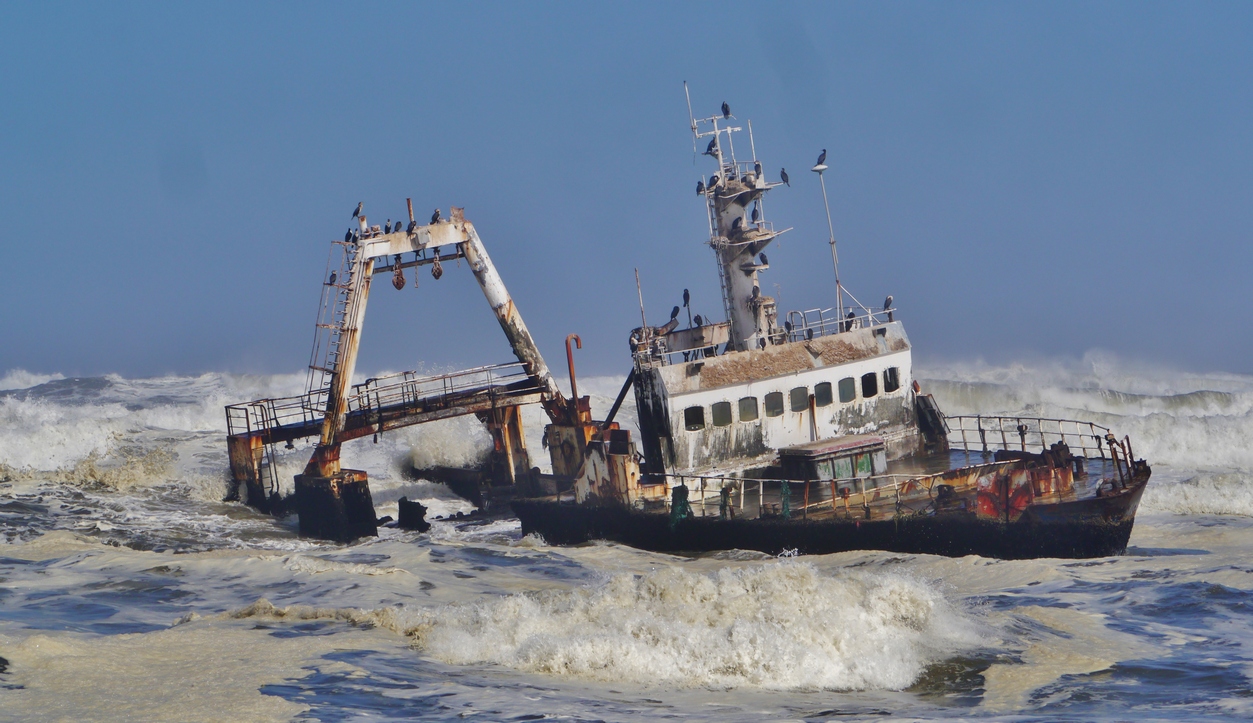
9.1. "Black Prince" |
1910/ Luderitz |
1917: Wilfried Metje, sent to Hannover in 1910 for his schooling, is called up for active military service and shortly thereafter becomes a prisoner of war in France. The steamboat "Black Prince" is stranded near Lüderitz. The payload is valued at £300,000. Metje buys the wreck for £1,000. However, when setting out to salvage the load he discovers, to his disappointment, that the ship has sunk completely, and that nothing more than the smokestacks are to be seen. | - |
| - | - | - | - |
|
9.2. "Bradford City" |
01.11.1941 | - | - |
| - | - | - | - |
| 9.3. "Brandaris" |
05.08.1968/ 12 miles north of Conception Bay |
- | - |
| - | - | - | - |
|
9.4. "British Prince" |
01.11.1915/ Possession Island |
- | - |
| - | - | - | - |
| 10. "Canute" |
March 1861/ Ichaboe Island |
- | - |
| - | - | - | - |
| 10.1. "Catherina D" |
1887/ Hottentot Point |
This sailing barque foundered offshore, west of Hottentot Point. | - |
| - | - | - | - |
|
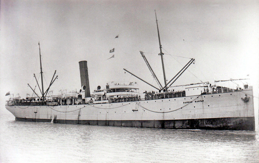
11. "Cawdor Castle" |
30.07.1925 |
The Cawdor Castle was stranded on 30 July 1925 and its wreck is located south of the famous Eduard Bohlen wreck. Hundreds of Germans were deported on Cawdor Castle in 1919 when South Africa had taken full control over the German South West Africa (presently Namibia). Interestingly enough, Cawdor Castle cargo included large number of whiskey crates. |
 |
| - | - | - | - |
|
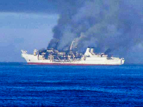
12. "Chamarel" |
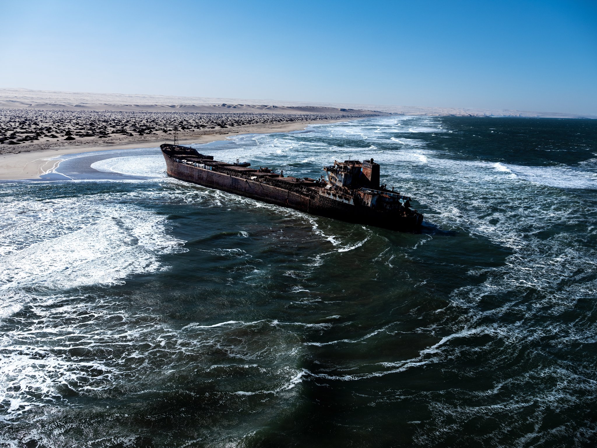
09.08.2012 | Chamarel was a French cable laying vessel caught fire on 08 August 2012 and was drifting off Namibia, abandoned by crew. Fire broke out when vessel was 68 miles north of Henties Bay while laying cable from Cape Town to Europe. Chamarel crew (56 people) was rescued by Namibian patrol boat Nataneul Maxwilili and brought to Walvis Bay. No injuries or casualties were reported. Chamarel was finally stranded 30 km off Henties Bay on 10 August 2012. Resolve Salvage & Fire Inc. undertook the wreck removal. Chamarel was pulled to the beach using a total of 13 chain pullers. The scrapping teams dismantled the 5000 mt of hull into smaller pieces. All scrap pieces were sold to a local scrapper for final processing. Resolve fully completed the wreck removal in July 2013. Chamarel's technical specifications: 135 meters (442 ft 11 in) long, 18 meters (59 ft 1 in) wide. Gross tonnage: 8,575, deadweight tonnage: 5,900 tons. Maximum speed: 12.9 knots (23.9 km/h), average speed: 11.2 knots (20.7 km/h). |
|
| - | - | - | - |
|
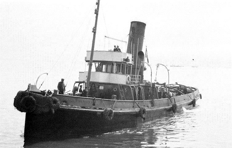
13. "Sir Charles Elliott" |
03.12.1942/ Rocky Point |
The tug Sir Charles Elliott arrived at
Dunedin Star wreck site from Walvis Bay on 02 December 1942. She had at
once closed the wreck of the Dunedin Star. The motorboat of the
Temeraire put the 43 rescued men on board the tug, which, with
difficulty, managed to get alongside the Manchester Division and
transferred them. Captain Lee, Chief Engineer Tomlinson and 2nd Senior
Engineer McGee remained on the tug and were put onto the minesweeper
Nerine. After leaving the wreck on 3rd Dec. the tug had set her course for Walvis Bay. At midnight Capt. Brewin handed over the watch to the second mate, Mr. Tommy Cox, and turned in. He was awakened about six o'clock next morning by the sound of a crash and a feeling of intense jarring. The treacherous current, combined with a shifting coastline and inadequate charts, had lured one more vessel to destruction a short distance north of Rocky Point. Captain Brewin and his crew, fighting against the raging surf and the Benguela Current, manage to get ashore. Tragically, Angus McIntyre 1st mate and Mathias Koraseb African deckhand failed to make it ashore and their lives were lost. On the 8th Dec. Capt. Smith and his Land Convoy arrived, ferried the survivors to Lt Col. Joubertĺs Ventura Bomber and were flown back to Walvis Bay. The SS Sir Charles Elliott, a South African rescue steam tug, ran aground and was wrecked at Rocky Point on return trip to Cape Town after MV Dunedin Star rescue operation. Casualties: two crew members lost their lives while trying to swim ashore. The grave of Mathias Koraseb is still at Rocky Point, second sailor's body was never found. Builder: Fleming & Ferguson Ltd., Paisley. |
 |
| - | - | - | - |
|
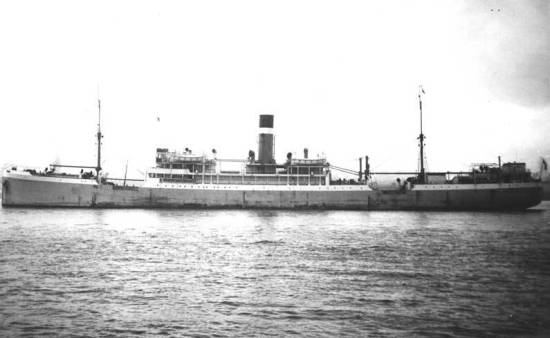
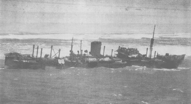
14. "City of Baroda" |
02.04.1943/ 90 miles south of Luderitz |
"City of Baroda" SS: 7130 ton British cargo merchant steamer built in 1918 by Barclay, Curle & Co Ltd, Whiteinch, Glasgow (yard number 526) and owned by Hall Line Ltd, Ellerman Lines Ltd, London. She was torpedoed by German submarine U-509 and sunk when en-route from London to Walvis Bay, Durban, Colombo and Calcutta via Trinidad in Convoy NC-9 carrying a 7 000 tons of general cargo, 1 500 bags of mail and 203 passengers. 11 persons lost their lives from a total of 331. U-509 was part of Gruppe Seehund (patrol group of five U-boats). Convoy NC-9 comprised two ships. On April 2nd Witte found the small convoy south of Walvis Bay. Approaching submerged he fired a salvo of 4 torpedoes by sonar bearings at extreme range. Astonishingly two torpedoes hit "City of Baroda" after 3 minutes and 40 seconds. The badly damaged ship was towed to Luderitz on 7th April 1943, where she was grounded. She broke in two and was declared a total loss. At 22.00 hours on 2 April 1943 the "City of Baroda" (Master Charles Stuart Nelson) in convoy NC-9 was hit by one of three torpedoes from U-509 about 90 miles south of Luderitz Bay, South West Africa. The badly damaged vessel was abandoned by the crew and two days later drifted ashore in 27░31S/15░19E and became a total loss after waves broke up the wreck until 26 April. One crew member and twelve passengers were lost. The master, 129 crew members, four gunners and 191 passengers were picked up by HMS Cape Warwick (FY 167) (T/Lt W.E. Goggin, RNR) and landed in Cape Town. Builder: Barclay, Curle & Co. Ltd., Whiteinch (Glasgow). |
|
| - | - | - | - |
|
14.1. "Clara and Florence" |
1873/ Ichaboe Island |
The vessel was lost north of Hottentot Bay near Ichaboe Island. | - |
| - | - | - | - |
|
15. "Collinstar" |
February
1965/ Chamais Bay |
Collinstar, the British standby tug,
sank near Chamais Bay in February 1965 with the loss of all six crew. Excerpt from "My Life on the MDC Diamond Barges" book (Mr. Terry (Lood) Terblanché): A tour of the barge revealed ten huge Caterpillar compressors, supplying the air to the airlift nozzles embedded in the seabed some forty to sixty metres below the surface. These compressors offered some comfort in the constant cold and damp conditions and if anyone was missing in action, you were sure to find him snugly next to a compressor! The air pressure was allowed to build up somewhat and then released into the nozzles. Once the air was released in the nozzle, the rising air inside the nozzles and pipes created enough suction to airlift tons of diamond-carrying gravel through sixty cm rubber pipes to the surface. Here it was first sieved in huge vibrating scalping sieves and later the finer stuff was sent through a cyclone. This apparatus separated diamond aggregate from most of the mussel shells and other gravelly matter. The separation took place by adding ferro-silicon to the water which was the transport medium for the gravel. The whole science in this system was that the whole mix of water, gravel, ferro silicon and what not was sent into the metal contraption under pressure. In the ensuing vortex, lighter and less dense matter ôfloatedö off on the top of the ôsoupö and left the cyclone to be discarded. The heavier and denser diamond carrying aggregate made it way to the bottom of the vortex where it was directed in a pipeline to the jigs in the sort house. Here the aggregate was collected in vibrating pans that through a brisk shaking action, got rid of the lighter stuff, leaving only the gravel containing gems in the middle. This whole lot is then sorted on the sorting table, hence the designation of the guy with the tweezers picking up the diamonds from the gravel pans which are I often wondered if the same system is used on land operation. Maybe one of the Oranjemunders can fill me in on this. By increasing or decreasing the addition of ferro-silicon one had a fairly good control on the recovery process. To check whether the cyclone was doing its work, a radioactive isotope was added to the ôsoupö from time to time. This was normally followed to the sort house with a Geiger counter. When we hit very deep deposits of shell, this was sent from the sort house jigs to a huge mill in which golf ball sized iron balls crushed the shell. When full, the mill discharged its content into separate containers and sorted in the normal way. Occasionally the clay and sediment used form such a thick layer inside the mill that it had to be cleaned manually. Obviously yours truly had to be present in that confined space! A system of counterbalances kept the nozzles in place on the seabed. Without them the barge would simply lift the nozzles out of the seabed with every rising swell. On Barge 111 they did not have the luxury of an automatic air release system like on the more modern Colpontoon. Here a dredging operator manually released the air by manual valves. If he dozed off, and it DID happen, a nozzle would dig in and get stuck. When the barge rised on a swell the cable tying it to the winching mechanism, would break under the strain. When this happened the specific counterbalance landed on the deck with a thunderous crash, waking friend and foe. Each barge had a diver, normally an ex-Navy guy, on board. This poor sod had to dive in icy, pitch black water down to the nozzle to secure a fresh cable to the nozzle. The diver was dressed in a rubber diving suit and wore a diving helmet which was attached to the suit itself. Attached to all this was the lifeline and of course the vital air hoses. Without any thermal protection the diver had very limited time to do the repair and often emerged from the sea blue with cold and shaking like a reed. It also happened that when the barge was to be moved to find fresh gravel, the nozzles had to be raised clear of the seabed. If the nozzles got stuck for some reason, the cables would snap as well. The dredging operator was normally on the receiving end, guilty or not. On the 111 this poor guy sat out in the open on the very end of the stern of the barge. On days with a heavy swell running the stern dipped so deep in the water that he often had to abandon his post for safety reasons. On the Colpontoon the dredging operator did duty in a comfortable enclosed cabin. Towards the end of my first trip I had a very traumatic experience. The sea was extremely restless when the shift knocked off. Not long after I dozed of into an uneasy sleep, the alarm sounded and all was evacuated from the crew quarters. Outside a horrific scene met our eyes. The Colpontoon rode on gigantic swells, dwarfing the two tugs in attendance. When the barge sank into a trough, not even the tips of their masts were visible. We now learned the barge was in grave danger. The starboard bow anchor cable snapped, causing the barge to swing to port. This offered an exposed flank to the swells. Given the enormous size of the barge, imagine the strain on the remaining cable. Thus it was not very long before the bow anchor cable on the port side snapped. I will try to explain the anchor system on the barges. The barge was anchored by four massive anchors: two on the bow side and two on the stern side. The bow was facing the ocean and the stern facing the shore. These were taken out diagonally away from the barge by a tug. The anchor was dropped some thousand plus metres away and marked with a buoy. Tethered by the four anchors, the Leading Hand could maneuver the barge large distances by winching in a given anchor and releasing the cable to the anchor on the opposite side of the one being winched in. This he did when diamond-carrying gravel became unproductive and he had to look for fresh deposits on the seabed. The importance of the bow anchors to keep the barge from becoming adrift speaks for itself. The barge was now dead meat and with the remaining bow anchor dragging it was only a matter of time before we were in the breakers. The two tugs tried in vain to secure tow ropes to the barge. They simply snapped time after time. Darkness was now approaching fast and the captain of the smaller tug, the Collinstar, tried a final run to secure a tow rope to the barge. Unfortunately, in the life and death struggle against mountainous seas, the captain could not watch the sea and the vessel he was trying to rescue and an enormous wave capsized the tug. She was now floating and rolling bottom up and she hit the barge several times with devastating effect. Later huge, gaping holes told the tale of what happened to the ill-fated Collinstar. I grew up on the sea but looked with new respect at the might of an angry sea. While this drama was unfolding, I at one stage disregarded instructions to stay on the upper deck. I was standing on the lower deck next to a huge H-beam, to watch the Collinstar. When the wave that capsized the Collinstar approached, I ran for dear life to the safety of the middle deck. That wave hit the barge with unimaginable force, simply running through it. Later on the beach, I found that that specific massive H-beam had snapped! By now it was dark and fortunately the generators on the barge were all running smoothly. We could see well enough to pick up survivors from the stricken tug. Seven did not make it. One of the guys was smashed to pulp against the barge. It is a sight one never forgets seeing a body that looked like tenderized steak. I guess it must have been in the early morning hours when the sea deposited the Colpontoon so high on the beach that we could disembark on Terra Firma in the early morning. To our utter disbelief, the Collinstar broke in two during the night. One half was some hundred meters south of us and the other half the same distance to the north. Strangely both halves were lying upright in the breakers, which were much calmer than the day before. There is a slightly unclear photo of the Colpontoon lying on the beach on the internet when you enter ôMarine Diamond Corporationö and click on ôimagesö. Thankfully we suffered no loss of lives or serious injury on the barge. I think it was mainly because we were lucky to strand on a piece of beach totally free of rocks. It was not so with the Barge 77 which ran aground on the rocks south of Chamais Bay. After this saga the crew was airlifted to the landing strip and we went home for a break. Only a skeleton crew remained with the barge. Later I learned that during the salvage operation, the barge sustained even more damage when she was towed off the sand and over wreckage Collinstar. After the salvage operation the Colpontoon was towed to Cape Town dry dock by the Collinsea. |
- |
| - | - | - | - |
|
16.1. "Consortium Omega" |
09.07.1981/ Conception Bay |
MFV CONSORTIUM OMEGA (WB95) was a South African Purse Seiner that foundered near Conception Bay, 51 nm south of Walvis Bay in 1981. She was built by Fritz Nieswandt, Luderwitz, Sa and owned by Consortium Visserye. | - |
| - | - | - | - |
|
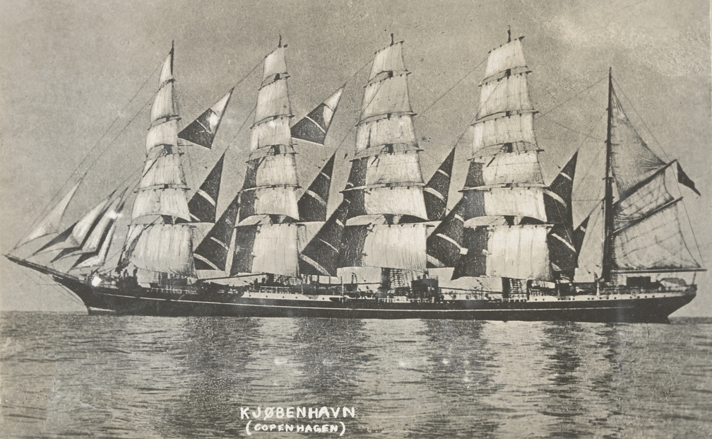
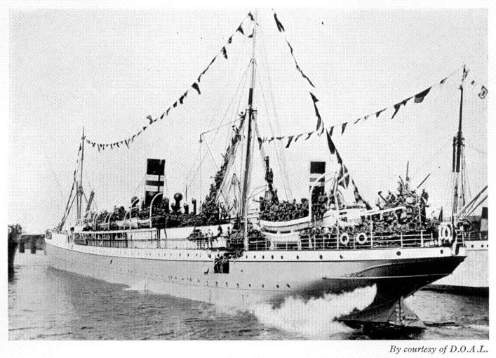
16.2. "Copenhagen (København)" |
1928 | The five masted Danish barque Kobenhavn
(Copenhagen) used as a naval training vessel until its disappearance
after December 22, 1928. The world's largest sailing ship, 3930 tons.
Built at Leith in 1921 for the Danish East Asiatic Company by the firm
of Ramage & Ferguson. The Kobenhavn was lost in 1928. Missing with all
hands when bound from Buenos Aires to Australia. The København
departed from Nørresundby in Northern Jutland for Buenos Aires on 21
September 1928 on its tenth, and final, voyage. The captain was Hans
Andersen; 75 persons were aboard, including 26 crew and 45 cadets. The
goal was to unload a shipload of chalk and bagged cement in Buenos
Aires, take on another load of cargo and sail for Melbourne, and then
bring a shipment of Australian wheat back to Europe. There is a number of theories for the København's disappearance as well as a number of sightings. In July 1930, the crew of an Argentine freighter sighted a five-masted
"phantom ship" during a gale. The captain took their statements and
wondered if this was the "wraith of the Copenhagen". Further sightings
came in the following weeks from Easter Island and the Peruvian coast.
Later some wreckage, including a piece of stern bearing the name "København",
was reportedly found off West Australia.
In 1934, the son of Argentinaĺs President visited the United States
telling a strange story. Men from a whaler working off Bouvet Island in
the South Atlantic had found a sealed bottle containing a Ĺlogĺ or diary
of a surviving cadet of the Copenhagen. The log told a grim story. The
Copenhagen struck an iceberg. There was no option for those aboard but
to take to the lifeboats. In the distance they saw their fine ship
crushed between two icebergs. The diary ended with "It is snowing and a
gale blows. I realize our fate. This sea has taken us beyond the limits
of this world."
Rumours, theories and searches for the lost barque have
continued ever since. In 2012 divers found a wreck on Tristan da Cunha
that some believe might be the missing ship. The Danish government and
the Danish East Asiatic Company were reportedly taking the suggestion
seriously enough to establish the truth of this possibility. But nothing
has since been reported.
The only trace of the Copenhagen disappearance were 7 skeletons, dressed
in torn sea jackets, found in 1935 in the Namib Desert in the Skeleton Coast
(Atlantic coast of Namibia). Anthropologists
confirmed that remains belonged to Europeans
judging by the skulls structure.
Patterns on
the copper buttons of the pea jackets which skeletons
were dressed in belonged to the uniform of the Danish merchant
fleet cadets as experts established.
Local tribesmen were questioned and according to them a several years
earlier they found a broken
boat on shore. It means that at
least one boat from the Kobenhavn reached the shore, but
sailors died of hunger and thirst on the deserted African coast.
The owners of the East Asian company no longer had
any doubts, because until 1935 only one training vessel of Denmark - the
Copenhagen - was lost. |
|
| - | - | - | - |
| 17. "Daphne" |
23.11.1845/ Ichaboe Island | The ship sank off Ichaboe Island, Portuguese West Africa. She was on a voyage from Ichaboe Island to Blyth, Northumberland. "Ship News". The Times (18833). London. 29 January 1845. col F. | - |
| - | - | - | - |
| 18. "Dee" |
06.02.1905/ Possession Island | SS DEE ran aground and was wrecked on Possession Island while on passage from Cape Town to Angra Pequina, SW Africa with general cargo on the 6th February 1905. Owned since 1902 by Cape of Good Hope SS Syndicate Ltd (e T Chaddock, Mgr) Cape Town. | - |
| - | - | - | - |
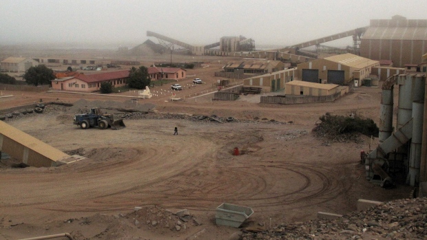
| 19. Diamond mine vehicles dump site |
28░26'09.22"S 16░16'06.37"E | Location: Oranjemund area.
The Consolidated Diamond Mines (De Beers) have
the largest diamond mine earth moving vehicle machinery fleet graveyard
in the world. Visits to diamond area are prohibited due to security reasons.
Once a vehicle has been used for diamond harvesting, it is not allowed
to leave the mine site anymore, even after end of its lifespan. Machines
of any types have been collected up in this graveyard since early
1900's. Possible reason is that people could find diamonds hidden in these old machines should it be released from prohibited area.
There are enough vintage machines to open a large museum. This graveyard of relics
portrait long history of the Namibian diamond mining since first diamond
was found at
Kolmanskop
in
Sperrgebiet
by Zacharias Lewala.
There are some surplus Sherman tanks used to bulldoze sand, a train of
20th century railroad
cars with German markings and World War II battle tank with a British
insignia on it had a huge steel blade welded in front of the gun turret
as De Beers converted these tanks to bulldozers. GPS coordinates: 28░26'09.22"S 16░16'06.37"E |
|
| - | - | - | - |
| 20. "Diaz" |
08.02.1926/ Northcliff near Saddle Hill | - | - |
| - | - | - | - |
| 21. "Dolphin" |
18.01.1960/ Conception Bay | - | - |
| - | - | - | - |
|
22. "Dunedin Star" |
29.11.1942/ north of Cape Fria |
The Dunedin Star was 13 000 tons British
refrigerated cargo passenger liner, designed to ship frozen meat from
Australia and New Zealand to the United Kingdom. It stranded on 29 November 1942, 40 km south of the Kunene River
mouth and
north of Cape Fria
with 106 passengers and crew members on board. 42 people managed to get to the shore, the rest were rescued by
Norwegian cargo ship Temeraire.
Various rescue attempts were undertaken from
Cape Town, Walvis Bay and
Windhoek. A Lockheed Ventura bomber plane was sent
from the Cape of Good Hope (Cape Town) to land with supplies and water for survivors who had made it to shore.
Unfortunately plane bogged down on landing in deep loose
sand. A second bomber was sent to replenish
supplies but it did not land, merely dropping its supplies. Second plane crashed into the ocean on the
way back. The three crewmen made it to shore and began their long walk
south. A
Walvis Bay tug boat, SS Sir Charles Elliott and two of its crew members
were also lost just north of Rocky Point during the rescue attempt.
The crew of the stranded tug attempted to row a dinghy with five
volunteers ashore, but it capsized. Three were washed out onto the
beach, more dead than alive. Mathias Koraseb somehow managed to climb
back onto the tug. The other man, first mate Angus McIntyre, carried
away by the current, was never seen again. The next day, Koraseb and two
others, wearing life jackets, made a desperate attempt to reach the
shore. They managed to do so, but Koraseb died a few minutes after
reaching safety. His grave is on the beach north of Rocky Point. With
five men ashore, the heavy lifeboat was launched
and rowed through the surf to the tug and rescued all their surviving
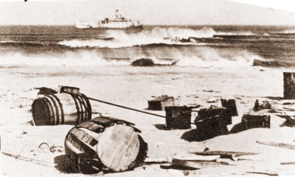
shipmates. A land rescue convoy, led by Captain Smith of the South African Police, set out from Windhoek through Kaokoland and the Namib Desert to reach those survivors who were ashore. The convoy reached the beach and rescued those survivors who had not been transferred by lifeboat to the Nerine, a converted minesweeper. Smith's 11 trucks got back to Windhoek on 23 December, where the survivors stayed before continuing overland by train. The valuable cargo of war materials was totally lost. The hundreds of rubber truck tyres destined for the Eastern war front, washed up on the Skeleton Coast National Park, but now up to a kilometre inland can be seen even now. |
|
| - | - | - | - |
|
22.1. "Dunmuir" |
1971/ Walvis Bay |
This fishing vessel foundered NNW of the Walvis Bay area. | - |
| - | - | - | - |
| 23. "Eagle" |
26.05.1861/ south of Sandwich Harbour |
- | - |
| - | - | - | - |
| 23.1. "Ebbtide" |
1969/ Pelican Point |
This motor powered fishing vessel wrecked at Pelican Point. | - |
| - | - | - | - |
|
24. "Eduard Bohlen" |
05.09.1909/ Conception Bay |
"Eduard Bohlen": 2,272 ton/95 m long,
single screw, speed 10.5 knots,
German passenger / cargo ship (Woermann Line).
Passenger accommodation: 1st Class: 32, 2nd Class: 14. Completed in
January 1891 by Blohm & Voss,
Hamburg (Yard No.75) for Die Africanische Dampschiffs AG (managed by
Woermann Line), Hamburg and used on the Hamburg - West Africa route.
1895 sold to Cie. Maritime Belge du Congo, Antwerpen. "Eduard Bohlen"
was repurchased by Woermann Line, Hamburg in 1898.
It was en-route from
Swakopmund to Table Bay and
ran aground at Conception Bay on 5 September 1909 in thick fog when it
was due to offload equipment for the diamond workers near Conception Bay
on her voyage from Swakopmund to Table Bay. After offloading of some
cargo and equipment aboard the Eduard Bohlen marine vessel Otavi attempted to tow the Eduard Bohlen
from the sandbank. Unfortunately the attempt failed, 30 passengers disembarked and were
transported to Swakopmund. Within next ten days, according to reports, so much sand settled
around the Eduard Bohlen that it was possible to walk from the beach to
the stranded ship at low tide.
It is 800 m inland now and partially buried under the
desert sand. Ships register shows that two ships named Eduard Bohlen were
built. The first Eduard Bohlen was built in 1889 for the Woermann Line,
but ownership was immediately transferred to the Deutsche Ost-Afrika
Line and the ship was renamed Reichstag. The second Eduard Bohlen was a
combination of passenger liner and cargo carrier. She was built by Blohm
and Voss, in Hamburg, also for the Woermann Line. She was launched on 23
October 1890, and delivered on 28 January 1891. A rare sight occurred between July 15 and 20, 1904 in Swakopmund: offshore lay 14 sailing ships and steamers, including the Eduard Bohlen, the Balgowan, the Nautilus and the Ingrid, all of which eventually came to grief along the Namibian coast - with one exception: the Ingrid ran aground no fewer than three times - and was put afloat three times again. In the thirties, Eduard Bohlen served to accommodate contract labourers working the diamond mines. South of the Eduard Bohlen lies the wreck of the Cawdor Castle, stranded on July 30, 1925. In 1904 at the beginning of the Herero Uprising, the German Schutztruppe took a decision to transfer Hereros living in Swakopmund , and those prisoners captured during the first days of the uprising onto the Eduard Bohlen, which was anchored off Swakopmund. Unsure of what to do with 282 male prisoners, the German authorities decided to offer the male prisoners to South African labour contractor A. Hewitt as workers for the mines. Hewitt was prepared to accept the prisoners, but refused to pay the 20 Mark customs duty per labourer. He reasoned that as the labourers men were already at sea and technically outside the customs area, the duty should be waived. Once the colonial administration agreed, the Eduard Bohlen set sail on 20 January 1904 for Cape Town, technically becoming a slave ship. Diamond miners in the vicinity decided that Eduard Bohlen was ideally located and perfect for workers accommodation. Tthe manager of the mine was allocated the captain's quarters. When mining operations ceased the Eduard Bohlen was finally abandoned to the sands. GPS coordinates: -23.996155, 14.457339 |
|
| - | - | - | - |
|
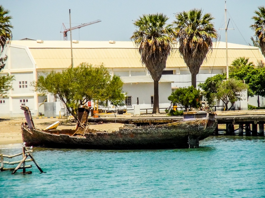
24.1. "Elena V" |
Luderitz | "Elena V" shipwreck in Second Lagoon, Luderitz |
 |
| 25. "Eliza" |
1840s/ Ichaboe Island |
- | - |
| - | - | - | - |
|
26. "Erycina" |
04.09.1896/ Cape Cross | In 1896, the "Erycina", a sailing Norwegian bark vessel belonging to the Damaraland Guano Company sank while it was offloading coal and supplies and loading guano destined for the U.K. when strong winds blew her ashore. Additional pumps were supplied at Cape Cross, but after two days it was found that she could not be kept afloat. It was finally decided to beach her. "Erycina"'s crew was taken back to Europe by the Woermann Liner, Lothar Bohlen. Over the years many wooden parts of this ship were washed ashore in the bay north of Cape Cross. There are no recognisable traces of "Erycina" today. | - |
| - | - | - | - |
| 27. "Flora" |
31.03.1859/ south of Walvis Bay |
- | - |
| - | - | - | - |
|
28. "Forester" |
February 1897/ Cape Cross |
The sailing vessel "Forester" was grounded at Cape Cross in February 1897. | - |
| - | - | - | - |
|
29. "Frotamerica" |
25.03.2013/ near Anichab Rocks |
The Brazilian
35 000 tons bulk cargo Frotamerica, built in 1979 by Estaleiro Ilha, on tow by MV
SKUA to the scrapers, lost her tow and was wrecked near Anichab Rocks
on 25 March 2013, no casualties reported. The wreckage
and oil pollution present a threat to wildlife along the coast. GPS coordinates: -26.370131, 15.040215 |
|
| - | - | - | - |
|
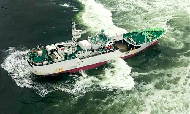
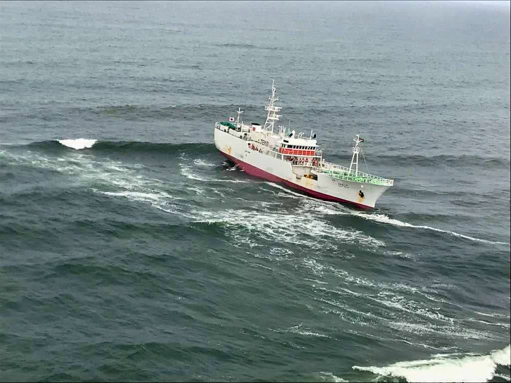
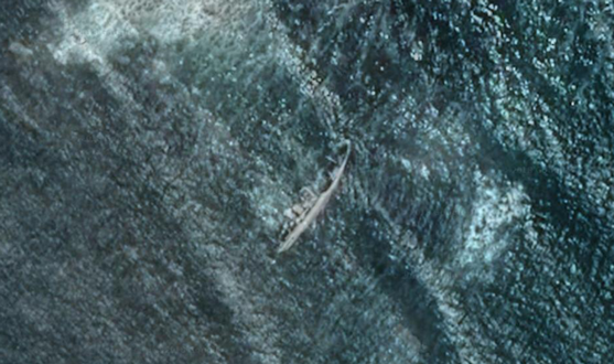
30. "Fukuseki Maru" |
22.03.2018/ Mile 108/ -21.308333, 13.695838 |
MVF "Fukuseki Maru No 7",
Japanese tuna fishing longliner vessel ran aground
near Mile 108, south of Ugab River estuary, near Durissa Bay,
on 22 March 2018. The ship was en-route with tuna catch from Angola
fishing grounds to
Walvis Bay.
It grounded on coastal rocks, crew evacuated. Navigational error was the
cause of this accident. IMO 9141223, Call sign JEKB, GT 577, built 1996, flag Japan. Present wreck's location GPS coordinates: -21.308333, 13.695838. |
|
| - | - | - | - |
| 31. "Gamsberg" |
02.06.1981/ Sandwich Harbour | - | - |
| - | - | - | - |
| 32. "Gedenksteen" |
North of Terrace Bay | - | - |
| - | - | - | - |
|
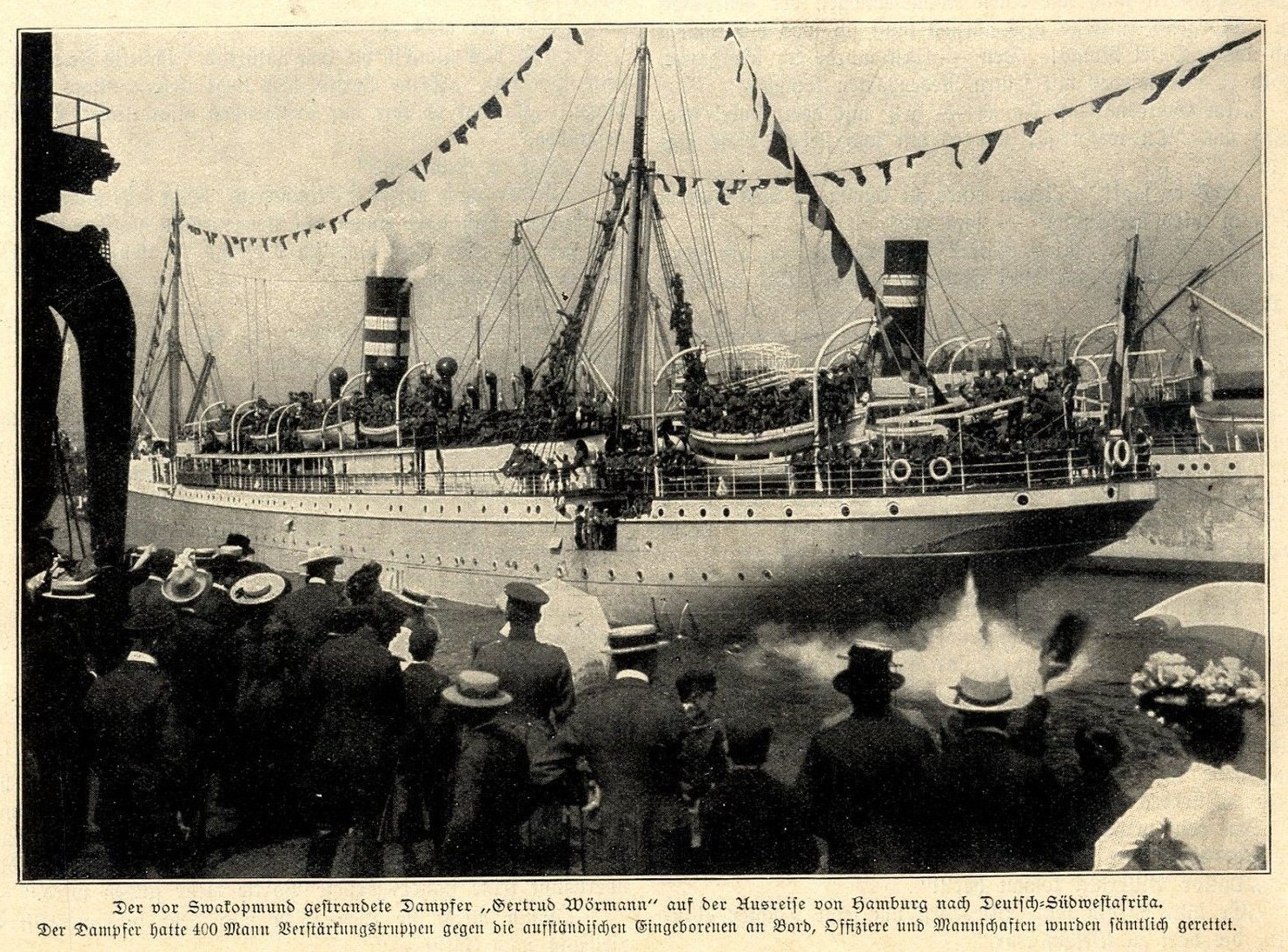
33. "Gertrud Woermann II" |
20.11.1904/ 30 km north of Swakopmund |
The Gertrud Woermann II, a 4 600 ton passenger / cargo ship of the Woermann Line ran aground in thick fog on a reef 30 km north of Swakopmund on 20 November 1904. She was built by Wigham Richardson at Newcastle and carried 400 soldiers, 375 horses, war material, mail and general cargo. Only one year later, her sister ship, the Gertrud Woermann I, was wrecked at Port Nolloth in South Africa. The gunboat Vineta, at that time on a visit at Swakopmund, assisted with the salvage operations, giving Swakopmund's north suburb its name. No lives were lost. The Gertrud Woermann wreck was visible until 1912, when she disappeared under the water during a heavy storm. Only a beacon, "Gertrud Beacon", today marks the spot where she has sank. It is a popular fishing spot. |
|
| - | - | - | - |
|
34. "Gethen" |
26.01.1954/ Henties Bay |
Gethen, the fishing trawler, was stranded at Henties Bay's North Dune and became one of the most well-known shipwrecks at the west coast. The wreck was used by local anglers for fishing from her in high tide but nothing is lest of it as the rough Atlantic disintegrated Gethen's body to pieces. Many vessel pieces and artifacts were carried away by local visitors and parts of its structure was also used as firewood. The late Mr. Keet mentioned amongst others that the nameplate of this boat was kept as a decoration at one of the holiday houses at Henties Bay. It is possible that the engine block is still visible during low tide. | - |
| - | - | - | - |
| 35. "Guernsey Lilly" |
1840s/ Ichaboe Island |
- | - |
| - | - | - | - |
| 36. "Hans die Skipper" |
08.05.1970/ Conception Bay | - | - |
| - | - | - | - |
| 37. "Heideveld" |
August 1968/ South of Horing Bay |
- | - |
| - | - | - | - |
| 38. "Hendrik Ibsen" |
1896/ Cape Cross |
There is a small graveyard near the seal colony at Cape Cross, bordering Atlantic Ocean with old weathered wooden crosses as witnesses of harsh conditions endured by the men on the isolated barren coastline without adequate supplies of fresh fruit and vegetables that made them susceptible to scurvy. The ships that carried supplies and transported the Cape Cross riches back to Europe were carriers of disease and their sailors were prone to scurvy. Without a harbour and with the strong seas and winds, several ships were wrecked along the coastline, including the Norwegian ship Hendrik Ibsent that sank off Cape Cross. One of the survivors, August Hasselund, subsequently worked for the Damaraland Guano Company for many years. After World War I he again worked at Cape Cross for another concessionaire and died in 1959. | - |
| - | - | - | - |
|
39. "Henrietta Spasheti" |
14.07.1968/ 165 nautical miles north of Walvis Bay, near Koigabmond |
"Henrietta Spasheti", the 90-foot trawler, ran aground on 14 July 1968 while moving inshore to fix their bearings, under command of Captain W.S. Gillion. The incident occurred 165 miles north of Walvis Bay. The crew of ten was able to get ashore safely in a life raft. Police Landrovers under command of G. Brand and Port Captain Bob Harding brought them back to Walvis Bay. This wreck can be seen at the most southern border of Torra Bay. Nature Conservation erected a signboard north of the Ugab River, on the Torra Bay road. |
 |
| - | - | - | - |
| 40. "Heraclides" |
26.10.1907/ Hottentot Bay | - | - |
| - | - | - | - |
| 41. "Hoeveld 1" |
23.11.1968/ north of Meob Bay (Fischersbrunn) | - | - |
| - | - | - | - |
| 42. "Hondeklip" |
July 1928/ Meob Bay |
The accident reason: fire on board. | - |
| - | - | - | - |
| 43. "Hope" |
14.05.1804/ south of Walvis Bay |
In 1804 the American whaler Hope was lost just south of Sandwich Harbour. Except for two survivors who were rescued in the Sandwich Harbour lagoon, all crew members were murdered by Strandlopers. | - |
| - | - | - | - |
|
44. Horing Bay wreck |
- | From time to time anglers mention a large steel wreck being visible at low tide near Horing Bay. Its origin is unknown. Presumably it is a wreck from the pre-colonial period. David Krynauw tried to find references in this regard but without success. No clues could be traced at Lloyds registers of London either. | - |
| - | - | - | - |
| 45. "Hunsbrook" |
07.11.1919/ 9 miles south of Walvis Bay |
This steel steamship was stranded in fog and wrecked on Pelican Point in Walvis Bay in Namibia. | - |
| - | - | - | - |
|
46. "Irmgard" |
1978/ Grosse Bucht, Luderitz |
"Irmgard" wreck is located in Luderitz Grosse Bucht ("Large Bay"), a bay along the coast near coastal town. The vessel belonged to the father of Mr. Ulf Grunewald, Luderitz Nest Hotel's owner. Mr. Hans Kustner built the boat in his garage in the space of a year, so that he could catch crayfish. He named it after his sister, Irmgard, and used it for a long time before selling it and moving to Windhoek. Upon its initial launch, it was the first flat-bottomed steel boat to be built in Luderitz. Unfortunately, the new crew was asleep on the boat one night when a terrible storm caused the anchor to break off from the boat which was then strewn onto the rocks and eventually onto the beach at Grosse Bucht in 1978/1979. Now only a skeleton of the boat is visible. |
|
| - | - | - | - |
|
47. "Islander" |
July 1973/ Rocky Point |
In July 1973 the 21 metre 139 gross ton fishing vessel Islander, registered in San Diego, USA, ran aground about 70 km north of Rocky Point close to the Angolan border. It was built in San Diego in 1972 with a powerful 630 hp diesel engine. One of the crew lost his life, while the others managed to reach the shore safely. As they had not managed to send a distress signal, no one knew of their predicament. The captain and first officer decided to walk to Rocky Point to look for help. While this was happening, Bernabe de la Bat, the director of the division of Nature Conservation and Tourism of the South West Africa Administration, was on an inspection flight in the Skeleton Coast National Park. On the flight, they saw a vehicle driving in the park. At the time, the conservation department was having problems with people illegally entering the newly proclaimed park. Suspecting the occupants were on an illegal fishing trip, they flew low over the vehicle and from its registration number, deduced it was from another government office further east. De la Bat was tempted to have the culprits apprehended by his rangers. For reasons of inter-departmental diplomacy, he decided not to pursue the matter and left the culprits to continue their journey. This decision probably saved the lives of the Islanderĺs crew. When the two exhausted men finally staggered to Rocky Point, they found their saviours fishing. Fortunately, they had a radio in the vehicle and could summon help. Had it not been for the illegal anglers, the aptly named Skeleton Coast would have claimed more victims. | - |
| - | - | - | - |
| 48. "Jane" |
1852/ Possession Island | - | - |
| - | - | - | - |
| 48.1. "Jenny Leonie" |
1971/ Walvis Bay |
This fishing vessel foundered in the Walvis Bay Harbour. | - |
| - | - | - | - |
| 49. "Kaiyo Maru" |
25.05.1978/ north of Cape Fria |
- | - |
| - | - | - | - |
| 50. "Karimona" |
September 1971/ north of Mowe Bay |
- |
 In 1978
|
| - | - | - | - |
| 51. "Kate" |
31.07.1926/ Possession Island | - | - |
| - | - | - | - |
| 52. "Kent" |
05.07.1850/ Hottentot Bay |
Barque. The historic significance and scientific potential. According to Kinahan (2009), the Kent shipwreck went down on the 5th of July 1850 long after the exhaustion of the Guano trade on the Namibian coast. It is reported that this was a passenger ship of British origin from Liverpool that sailed to Cape Town. It got lost in a south-west gale off Hottentot Bay. The ship was a three mastered 26-meter wooden vessel, and the little that remains of it is because its wood was broken up and used to build a jetty. This jetty is today used for loading at a crayfish factory. Werz (2007) specifically refers to it as a rock lobster factory, the jetties themselves in this context constitute artificial static sites and are part of the maritime and underwater cultural heritage due to their association with the sea. The passengers from the Kent were rescued by Captain Spence of De pass, Spence and Co. The story of the rescue is most important as well as studying what is left of the ship in understanding its design etc, thus interpretive and scientific potential is possible. |
- |
| - | - | - | - |
| 53. "Kolmanskop" |
15.08.2006/ Vierkantklip |
Kolmanskop, a fishing trawler, that belonged to Glomar Fisheries, ran
aground and wrecked at Vierkantklip, just south of
Swakopmund, after it
broke from its moorings in
Walvis Bay during strong winds. Kolmanskop
drifted to Vierkantklip and became stuck between rocks about 200 m from
the beach. Due to the hull damages It was not possible to refloat her.
Kolmanskop was dismantled in 2009. Nationality: Namibian, purpose: fishing, type: trawler, propulsion: motor vessel (diesel), date built: 1980, tonnage: 363 grt, dimensions: 34 x 9.5 m, material: steel, engine: diesel engine, single shaft, 1 screw speed: 12 knots, yard no.: 597, IMO/Off. no.: 7816068. Date lost: 15/08/2006, casualties: 0. Builder: Goole Shipbuilding & Repairing Co. Ltd., Goole Lewis John & Sons Ltd., Aberdeen, engine by: Wichmann Motorenfabrik, Rubbestadneset. |
|
| - | - | - | - |
| 53.1. "Kongefisk" |
1966/ Swakopmund |
This motor powered fishing vessel foundered off the Swakopmund coast. | - |
| - | - | - | - |
| 54. "Limpopo" |
01.01.1930/ Sylvia Hill | - | - |
| - | - | - | - |
| 55. "Lord Keane" |
1840s/ Ichaboe Island |
- | - |
| - | - | - | - |
|
56. "Luanda" |
1969/ north of Toscanini |
The Luanda was shipwrecked north of Toscanini in 1969. | - |
| - | - | - | - |
| 57. "Magna" |
21.07.1911/ Luderitzbucht Harbour |
Sank at Luderitz harbour |
 |
| - | - | - | - |
| 58. "Maria Angelina" |
1923/ north of Cape Fria |
Steel vessel, sank north of Cape Fria, Skeleton Coast National Park | - |
| - | - | - | - |
|
59. "Maridal" |
23.01.1926/ Possession Island | This vessel grounded on Possession Island
near
Luderitz. The steamboat "Maridal" |
- |
| - | - | - | - |
| 60. "Meob Bay" |
07.06.2002/ near Luderitz |
MFV Meob Bay, belonging to Marco Fishing, capsized off the coast of Luderitz in June 2002, resulting in the loss of 19 lives. It was worst ever maritime disaster in Namibia. It was sailing from Luderitz when disaster struck. A piece of drifting rope, attached to an anchor on the ocean floor, which had been left in the ocean, allegedly by a diamond-mining vessel, Lady S, which belonged to a South African-registered company, Gemfarm, was picked up by the MFV Meob Bay's propeller. With the rope becoming entangled in the propeller, the ship was doomed. Attached to the rope, the powerless vessel swung around to have its rear towards the swell which, with a strong wind of 36 knots, was between four and six metres high. Unable to ride the swell because it was fastened to the rope, the boat quickly started to take in water. Within a matter of five to ten minutes, she sank. Of the crew of 28, only nine survived. The bodies of 12 of the other crew members were later recovered from the bitterly cold water. The other seven crew members are still missing, presumed dead. With that, the sinking of the MFV Meob Bay was the maritime disaster with the highest death toll yet in Namibian waters. | - |
| - | - | - | - |
|
61. "Miscky" |
22.12.2013/ False Cape Fria |
The 43-foot sailing yacht "Miscky" was found on the afternoon of 22 December 2013 near False Cape Fria (Skeleton Coast National Park) in the surf on the beach. The boat was unmanned across the Atlantic after its owner, South African Mike Kuun, left the ship after a dramatic rescue operation on the high seas. "It was a strange find," said Johan van Rooyen, manager of Northern Namibia Development Company (NNDC). And: "At first we thought: Where are the people?" Van Rooyen found the owner after an extensive Internet search. However, Kuun was no longer interested in the ship. "He told us we could recover the valuables." But the ship itself will be another wreck on the notorious Skeleton Coast, because it was almost impossible to remove the 20 ton yacht. The surrounding area was a logistical nightmare for a rescue operation. According to various South African media reports, the owner of the "Miscky", Kuun, wanted to sail from East London in South Africa to the Caribbean. He and his girlfriend had first sailed to Saldanha Bay. His companion went ashore there and Kuun continued the trip alone. The next destination should be St. Helena Island. About 350 nautical miles from South Africa, he was in distress because of a defective rigging (sailing equipment). He had notified his girlfriend who triggered the emergency call. Kuun was saved by the "Aqua Fortune" oil tanker on December 22 and gave up the yacht that has been floating in the Atlantic since then. |
 |
| - | - | - | - |
|
62. "Montrose" |
June 1973 | The Montrose stranded in 1973 and can be seen just south of the southern
border of Torra Bay. This wreck has become a popular perch for
cormorants.
The Montrose II CDF 205 were build in 1963 by Louw & Halvorsen in Cape
Town. She was 67.5 feet long and were powered by a Caterpillar.
She was originally owned by Mr. R. Middlekop from Hout Bay and was used
as a purse seiner. She fished for Van Riebeeck Canning in Hout Bay as
well as the Ovenstone's factory, Columbine Canning in St. Helena Bay.
In 1970 she was sold to Mr. W. H Hearn from Hermanus are were converted
into a inshore trawler for catching Hake, Sole and Kingklip. Her area
code also changed from the Hout Bay area code (CDF 205) to the Hermanus
area code (C 145). During the late 60's and early 70's many south African fishing boats were fishing off the South West African coast line just behind the territorial 12 nautical mile boundary at that time. Thus the reason she stranded so far from her home port. |
 |
| - | - | - | - |
|
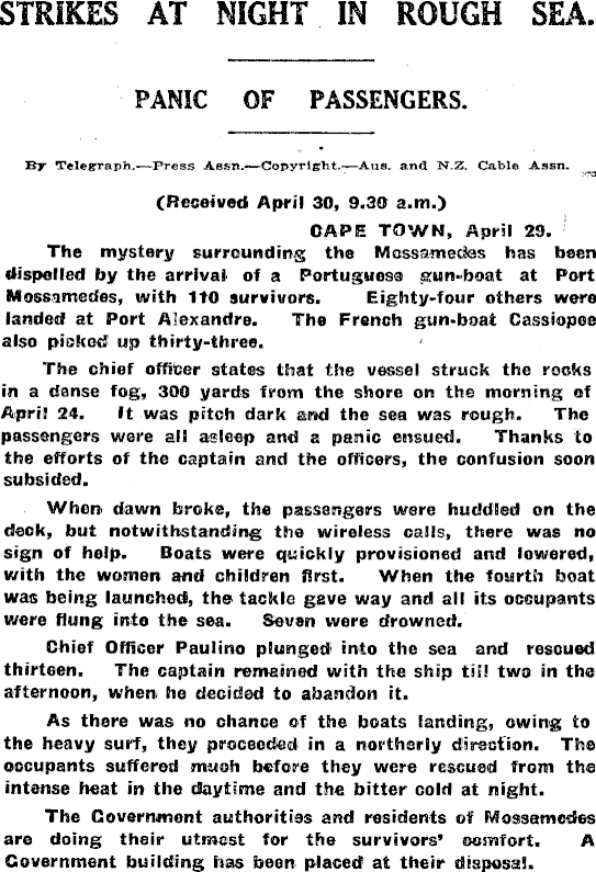
63. "Mossamedes" |
23.04.1923/ south of Cape Fria |
Mossamedes left the port of Lorenco Marques,
the present Maputo, on Friday, 13 April 1923, under protest of the
entire crew. The ship carried 143 passengers, her cargo consisting of 25
crates of dynamite, detonators and a vast quantity of sulphuric acid,
enough to create serious problems for the ship and its anxious crew.
Justifiably, because on April 23, 1923 the Mossamedes ran aground north
of
Swakopmund. As the captain feared detonation of the explosives, the
ship was evacuated without delay. The lifeboats, packed with crew and
passengers were lowered: one boat capsized, a crew member and seven
passengers drowned and another lifeboat carrying 23 passengers
disappeared, without a trace. The remaining survivors were picked up by
other ships that had hurried to the scene of disaster. From "Tales from the great north road the qreat Kaokoveld diamond raid" (2012 African Hunter Magazine): "The Portuguese steamer Mossamedes had been wrecked off Cape Frio in a dense fog seven years earlier. Of the 258 souls on board, six of the seven boats launched, containing 227 passengers and crew were picked up by rescue ships but the fate of the seventh boat remained a mystery. Until Suskin's party came across a large amount of flotsam on the beach at the cape. Deck chairs, ship's furniture, and dozens of demijohns of port wine - still drinkable! Suskin postulated that the boat had reached shore safely, but the survivors had died of thirst. When Suskin awoke the following morning having slept on a sand dune he noticed a pair of shoes nearby. Digging through the sand, he found a human skull. In all, they recovered thirty one skeletons amid the wreckage, and they buried them with what Christian honours they could. In a lighter moment, the porters had brought little in the way of clothing and were feeling the cold. When Suskin's party moved out, the natives were dressed in silk evening gowns from a steamer trunk. "It provided a little comic relief after the discovery of the skeletons" Suskin observed." Read: STRIKES AT NIGHT IN ROUGH SEA Merced Sun-Star, Volume 55,
Number 23, 27 April 1923 |
 |
| - | - | - | - |
| 64. "Nafsiporos" |
05.07.1969/ Chamais Bay | The Greek MS Nafsiporos, on passage Cagliari to Bombay with a cargo of fluorspar, was wrecked at Chamais Bay, west coast of Namibia. She was beached after springing a leak. | - |
| - | - | - | - |
|
65. "Natal Coast" |
30.04.1955 | The Natal Coast,
Durban coaster steamer of over 3000 tons, was stranded in thick fog
just north of the Gertrud Woermann II approximately 30 km north of
Swakopmund.
She was on her way from Matadi to Cape Town.
The crew of 35 abandoned the ship, which was pounded by heavy seas, only
a few hundred yards from the shore. It was told that the crew on this
ship was not permitted off the ship until armed guards arrived to
prevent sailors from picking up diamonds which were all over the beach.
On weekends school children from Swakopmund used to play on this wreck.
She had a large consignment of coconuts on board, which was a delicacy
at the time. A scrap dealer eventually dismantled her. Today only part
of her engine room and boilers are visible at low tide.
|
|
| - | - | - | - |
| 66. "Naustilus" |
06.03.1919/ Possession Island | - | - |
| - | - | - | - |
| 66.1. "Norma" |
1969/ Cape Cross |
The fishing vessel foundered near Cape Cross. | - |
| - | - | - | - |
| 66.2. "Nortun" |
1943/ Chamais Bay |
This Norwegian steamship freighter was torpedoed and sunk by U-516 west of Chamais Bay. She was in a convoy which left Cape Town on the 18th March headed for the Carribbean when she was lost, 8 crewmen and 2 armed guards died, 37 crew survived. | - |
| - | - | - | - |
| 67. "Oceana Star" |
26.02.1975/ Conception Bay | - | - |
| - | - | - | - |
| 67.1. "Ocean Queen" |
1984/ Swakopmund |
This motor powered fishing vessel foundered north of Swakopmund. | - |
| - | - | - | - |
| 68. "Oinoussai" |
28.08.1967/ 60 km north of Oranjemund |
- | - |
| - | - | - | - |
|
69. "Ontdekker I" |
1979/ near Walvis Bay |
A South African fishing vessel foundered near Walvis Bay | - |
| - | - | - | - |
| 70. "Orion" |
1840s/ Ichaboe Island |
- | - |
| - | - | - | - |
| 70.1. "Orca" | 1978/Palgrave Point | This motor powered fishing vessel capsized near the Uniab River, north of the Palgrave Point area. | |
| - | - | - | - |
| 71. "Otavi" |
1945/ Spencer Bay |
A steamer
ran aground in the forties whilst loading guano from Mercury Island. Ran
aground in Spencer Bay in 1945.
"Otavi" wreck was stranded at Spencer Bay's beach in a small
bay.
This wreck can only
be reached by foot or by sea. This resulted in the wreck being virtually
preserved untouched. GPS coordinates: -25.732391, 14.833276 |
|
| - | - | - | - |
| 71.1. "Patches" |
1967/ Walvis Bay |
This motor powered fishing vessel wrecked after a fire in Walvis Bay. | - |
| - | - | - | - |
| 72. Pelican Point wreck ("Pentaur"?) |
- | A wreck of a unknown small vessel near
Pelican Point Lodge
and
Lighthouse. From Mogamat Salie Saban (mogamat.s.saban67@gmail.com): The name of this Norwegian whaler is "PENTAUR", it was part of a group whalers that have hunted whales in the Namibian waters. |
|
| - | - | - | - |
| 72.1. "Pede A Deus" |
1969/ Conception Bay |
This motor powered fishing vessel foundered at sea north of Conception Bay. | - |
| - | - | - | - |
|
73. "SS Point Pleasant Park" |
23.02.1945 | SS Point Pleasant Park,
a merchant steamship,
was torpedoed 300 miles off the Namibian coast on February 23,
1945
by the German submarine U-510, skippered by Kapitänleutnant Alfred
Eick. Nine men were killed instantly, but the remaining crew were able
to reach Luderitz on lifeboats or were eventually rescued by another
ship.
Point Pleasant Park was the last vessel sunk in South African waters
during the Second World War.
Point Pleasant was built by the Canadian Park Steamship Company Limited,
a Crown Corporation set up in 1942 to aid the Allied war effort by
building and operating cargo ships to replace those lost to enemy action
and ensure an ample flow of supplies to Allied forces. The ship was a
10,000 ton version of the Canadian Park ship program, a design similar
to the American Liberty ships. She was built at Davie Ship Building &
Repair Co. Ltd. at Lauzon, Quebec and entered service the 8 November
1943. The ship was named after Point Pleasant Park in Halifax, Nova
Scotia, following the tradition of naming Park ships after Canadian
wilderness and recreation parks.
Owner: Furness Withy (Canada) Ltd, Montreal. Operator: Park Steamship Co Ltd (1943), Witherington & Everett (1944). Port of registry: Montreal. Builder: Davie Ship Building & Repair Co. Ltd. Tonnage: 2,878 GRT, 1,653 NRT. Length: 315 ft 5 in (96.14 m). Beam: 46 ft 5 in (14.15 m). Depth: 22 ft 9 in (6.93 m). Installed power: triple expansion steam engine. Propulsion: screw propeller. Crew: 34, plus 4 DEMS gunners. Armament: 1 x 4 inch deck gun aft, 1 x 3 inch (76 mm)/50 caliber gun, 4 x 20 mm Oerlikon, 2 x Twin .50 cal. Machine Guns 20 x Rail Anti-Aircraft Rocket Launcher (Pillar Box). Point Pleasant had mostly British officers, led by Captain John Everall, but otherwise the crew were Canadian. She left Montreal on 5 December 1943, bound for Cape Town, South Africa. She stopped at Halifax for minor engine repairs and while there, the mayor of Halifax, John Lloyd, presented Captain Everall, with a framed picture of the ornate gates to Point Pleasant which was hung in the officer's dining room aboard the ship. The Halifax Herald featured the ship on its front page in honour of the connection between the city's landmark park and the war effort. The ship left Halifax in a convoy on 9 December 1943, stopping at New York City and then Port of Spain, Trinidad where she refueled and continued in convoy. Off the coast of Brazil, she was detached from the convoy to sail alone to Cape Town arriving in early February 1944. The ship then called on Port Elizabeth, East London, Durban in South Africa and Beira, Mozambique before returning to Cape Town with a cargo of sugar. Point Pleasant sailed next to Lagos, Nigeria and collected a cargo of palm oil, peanuts and cocoa for Montreal where she arrived on 19 June 1944. Most of her crew re-enlisted for her second voyage, an indication of a happy ship, and she left Montreal on 3 July 1944 repeating a similar voyage in convoy as far as Brazil and then unescorted to Cape Town, East London and Durban before loading a cargo of manganese ore from Takoradi, Ghana which she delivered to Philadelphia. Point Pleasant arrived in Saint John, New Brunswick on 18 December 1944. There Captain Everall took another command. This class of "Park" ship carried four life boats, two small ones on either side of the Captain's deck, just below the bridge, and two larger ones on either side of the engine room. The smaller boats could hold about twelve people and the larger ones about twenty. The smaller one on the port side of the bridge was manned by the First Mate and a designated crew. The boat on the starboard side was commanded by the Third Mate. The large boat on the port side of the engine room was the Captain's, and had an engine. The fourth boat was the Second Mate's. The torpedo blast had destroyed the ship's radio antenna so no distress call could be sent out. The lifeboats plotted a course for the coast of South West Africa (Namibia), over 300 miles (480 km) away. The two life boats soon lost sight of each other. In one boat 21 sailors were crowded in space made for 11 or 12. Daily rations were 2 ounces of water per man, two spoons of pemmican (hard grain mixed with fat), two biscuits and a small piece of chocolate. The overcrowded boats endured blistering sun and survived a significant storm. The survivors were comforted when the Southern Cross constellation, which appeared each night, showed they were on course. Captain Owens and 19 crew members made landfall at Mercury Island on Namibia's Skeleton Coast on 2 March. There the fishing vessel Boy Russell found them, and took them to Luderitz, South West Africa. The South African naval trawler HMSAS Africana found the other lifeboat on 4 March, north of Spencer Bay. Africana landed the 29 crew members she had rescued, many injured, at Walvis Bay, South West Africa. After recovery in hospital, the survivors went by rail to Cape Town and eventually made their way back to Canada via the United States. The nine dead are: Joseph Bayliss (age 18), Alfred Malmberg (age 19), Leslie Toth (age 20), Louis Wilkinson (age 21), Patrick Guthrie (age 24), Frederick Breen (age 29), George Edwards (age 34), Ronald Hallahan (age 54), Robert Munroe (age 39). |
 |
| - | - | - | - |
|
73.1. "Poinsettia" |
1951/ Sandwich Harbour |
This fishing trawler wrecked in Sandwich Harbour in Walvis Bay area. |
- |
| - | - | - | - |
| 74. Portuguese gunboat |
1880/ Sandwich Harbour |
- | - |
| - | - | - | - |
| 74.1. "Prince Edward" |
1862/ Walvis Bay |
This sailing schooner wrecked south of Walvis Bay. | - |
| - | - | - | - |
| 75. "Princess Caroline" |
1755/ Meob Bay |
- | - |
| - | - | - | - |
|
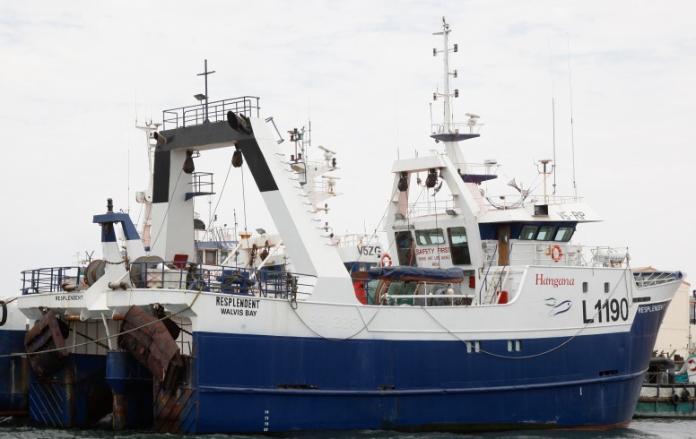
76. "Resplendent" |
18.02.2020/ Walvis Bay |
A fishing trawler, Resplendent, belonging to Hangana Seafood company, sank in the Atlantic Ocean on 18 February 2020 and its captain is missing. 26 crew members of the vessel were rescued by another vessel, the Fisher Bank, also belonging to the company. The trawler was owned by Ohlthaver & List Group, which is the parent company of Hangana Seafood. The Resplendent was one of the company's fleet of eight vessels. |
 |
| - | - | - | - |
|
76.1. "Rosandra" |
1931/ Pelican Point |
This steamship wrecked south of Pelican Point area. | - |
| - | - | - | - |
| 77. "Sea Flower" |
January 1969/ Sandwich Harbour |
- | - |
| - | - | - | - |
| 78. "Sea Star" |
1900/ Steeple Rock north of Luderitz |
- | - |
| - | - | - | - |
| 78.1. "Sette Mari" |
1985/ Cape Cross |
This motor powered fishing vessel wrecked at Cape Cross. | - |
| - | - | - | - |
|
79. "Shawnee" |
1976/ Conception Bay |
The 1976 shipwreck of the Shaunee, a fishing trawler, nosed into the dunes at Conception Bay. In the former diamond rush era of Namibian History, Conception Bay was the entrance towards the old mining towns of Grillenberger, Holstazia and Charlottenfelder. GPS coordinates: -23.672940, 14.503963 |
|
| - | - | - | - |
| 80. "Solingen" |
04.11.1904/ Hottentot Bay | Many of the lost ships that came to load guano were driven ashore by the south-westerly gales. Firewood for prospectors was available for many years. The Ichaboe island headman used to live in a chart house torn from the poop of a sailing ship, strengthened against the weather by timbers from other ships until the early 1930ĺs. When the German ship Solingen stranded in November 1904 at Hottentotĺs Bay, Emilio, the Italian headman from Ichaboe Island and some workers rowed over to replenish their supply of alcohol. During this unauthorised shopping expedition they discovered a piano in the dining saloon. On a subsequent excursion Emilio and some of his colleagues succeeded in hoisting the piano into their boat. It was a dangerous journey back but even more complicated to hoist the piano up the Ichaboe jetty and transferring it into their dining hall. They eventually succeeded with many scratch marks, a few blue finger nails and one broken leg of the piano. Despite the damages, the piano provided the workers with many happy moments for many years. | - |
| - | - | - | - |
|
81. "South West Kittyhawk" |
2001/ Namib-Naukluft Park, north of Luderitz |
- | - |
| - | - | - | - |
|
81.1. "Stormkus" |
1977/ Walvis Bay |
This motor powered fishing vessel foundered off Walvis Bay. | - |
| - | - | - | - |
|
82. "S.W. Seal" |
1976/ south of Toscanini |
A small piece of the South West Seal can be seen just south of Toscanini and signposted north of the Ugab River. It ran aground in 1976. Nature Conservation erected a signboard north of the Ugab River, on the Torra Bay road. It is one of the easier wrecks to reach. |
|
| - | - | - | - |
|
83. "Suiderkus" |
16.01.1977/ Mowe Bay |
The Suiderkus, a Cape Town-based trawler, owned by the Angra Pequena Viskoporasie, which cost R3,5 million to build, equipped with state-of-the-art navigation equipment, ran onto the rocks at Mowe Bay on her maiden voyage on 16 January 1977. In a few months the expensive trawler became rusted and derelict, reduced to a picturesque but temporary landmark. Parts of the ship are still visible today. There is a tiny museum at Mowe Bay filled with bones, human skulls, life vests from Japanese whalers, the figurehead of a galleon, brass cannons, rigging and numerous other remnants of wreckage. |
 |
| - | - | - | - |
|
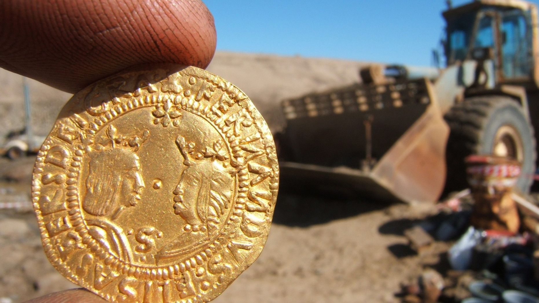
84. "The Bom Jesus" |
1533 |
The shipwreck was discovered by a Namdeb worker, Kapaandu Shatika on 1 April 2008. Diamond prospectors in Namibia nearly a decade ago stumbled upon remnants of a shipwrecked Portuguese vessel whose trading journey to India was cut short by a storm in 1533. Today the artifacts from the doomed ship, described by archaeologists as one of that era's most important finds, remain a hidden treasure. The remains of the ship owned by Portuguese King Joao III, identified by archaeologists as the Bom Jesus. While the fate of the crew of the Bom Jesus is unknown, the ship's relics include 2,266 Portuguese and Spanish gold and silver coins, pewter plates, cutlery handles, a brass medical syringe and goods that were to be traded for spices in India, ingots stamped with the trident symbol of a German trading house, and elephant ivory believed to have been transported from West Africa to Lisbon, the Portuguese capital. Wood planks from the ship's structure and weapon parts are kept in tanks of water, a conservation process that removes corrosion-causing salt. It is possible that the ship may be linked to Portuguese explorer Bartolomeu Dias, who went missing in 1500. The sunken ship's rich treasure includes a total of 2,266 gold and silver coins that were found underneath its planks. |
|
| - | - | - | - |
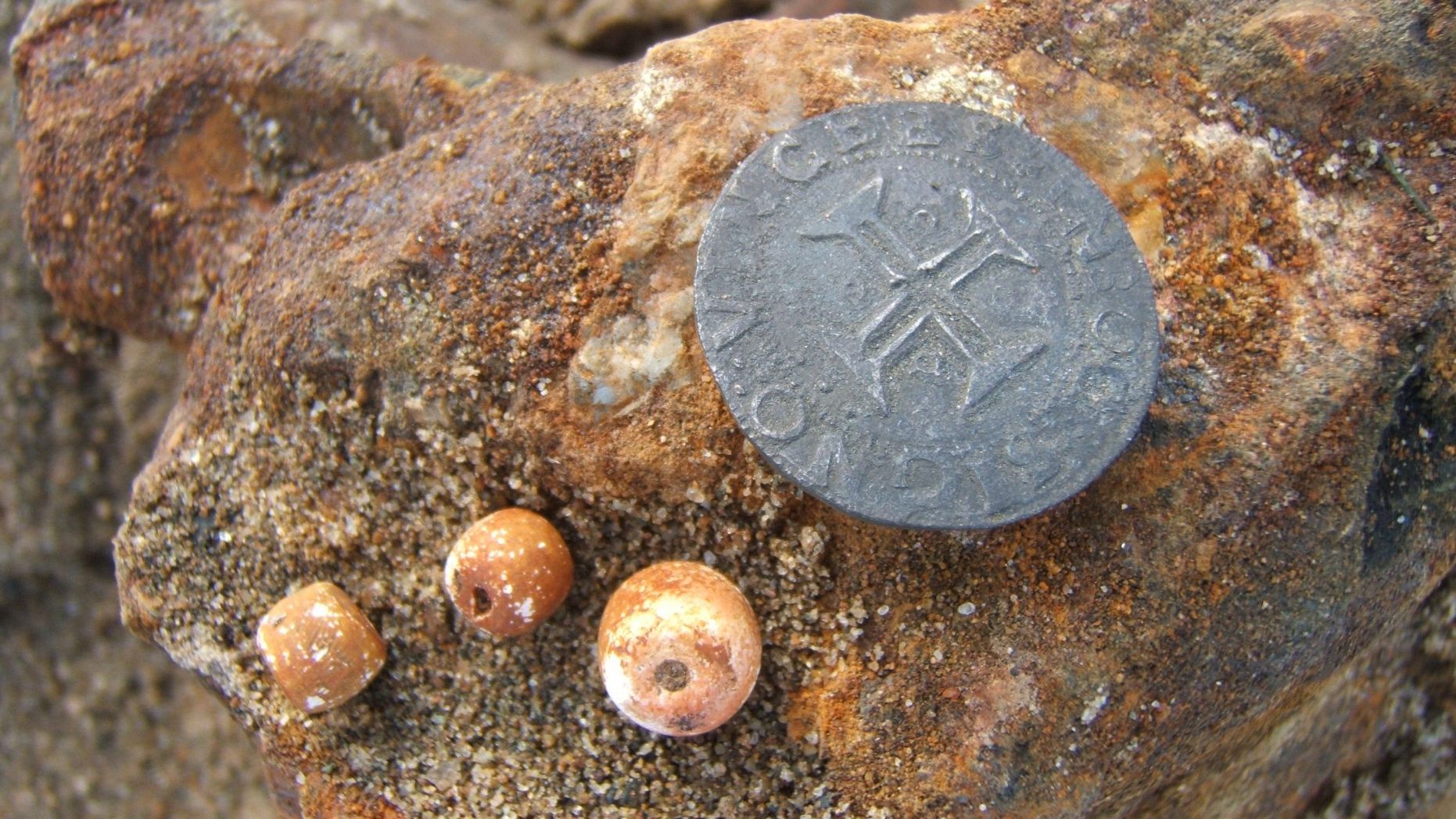
| 85. "The Vlissingen" |
1747 | Some 180km south of
Walvis Bay in a
hidden bay in an inaccessible beach area rests a Dutch shipwreck for
nearly 300 years now. Only now and then a rare expedition disturbs it at Meob Bay. Those lucky enough who were there, report of some antique
coins, called ôdoitsö washed up on the beach. These copper coins bear
the letters ôVOCö (Verenigde Oostindische Compagnieö ľ Unified
East-Indian Company). The Dutch VOC existed from 1602 until 1799 and
traded with India and Asia. In 1652 it started a storage station at the
Cape of Good Hope, todayĺs Cape Town. One of the VOCĺs ships called
ôVlissingenö probably capsized in 1747 at Meob Bay, according to Bruno
Werz. He wrote an article about it in the Journal of Namibian Studies,
2008. Werz led an expedition to Meob Bay. About 900 copper ôdoitsö
engraved with VOC were found there, many of them bearing their
manufacturing year of 1746. Research proved they were coined that year
in Middelburg, Netherlands. According to Werz (2007), the Vlissingen
was a Dutch East India Company (hereafter VOC ship) that was on its way
to Table Bay from Middleburg in the then Dutch republic. The ship was
likely carrying European goods for trade in the Far East where the Dutch
had overtaken the Portuguese in controlling the lucrative trade for
Chinese porcelain, Indian spices, and other commodities. Werz (2007)
stresses that the Vlissingen was identified based on the coinage that
washed ashore in Meob bay on the Namibian coast. It is thought that the
coins were minted around 1746 in the then Dutch Republic. |
- |
| - | - | - | - |
| 86. "Tilly" |
01.02.1885/ near Luderitzbucht Harbour |
- | - |
| - | - | - | - |
| 86.1. "Titania" |
1938/ Conception Bay |
This sailing schooner wrecked south of Conception Bay / Walvis Bay. | - |
| - | - | - | - |
| 87. "Tong Wha 107" |
17.04.1972/ 10 miles north of Spencer Bay |
This motor powered fishing vessel wrecked on Albatros Rock north of Luderitz. | - |
| - | - | - | - |
| 88. "Torness" |
05.12.1955/ Sandwich Harbour | - | - |
| - | - | - | - |
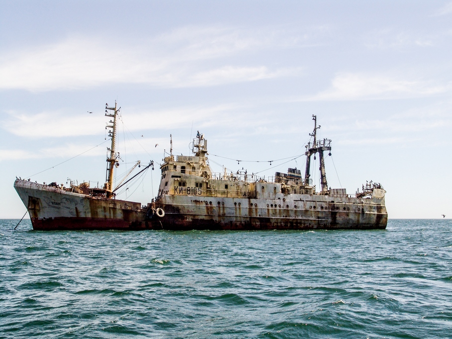
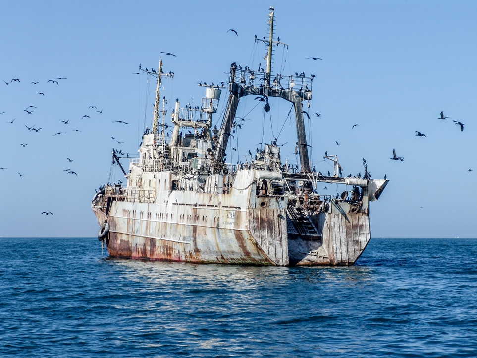
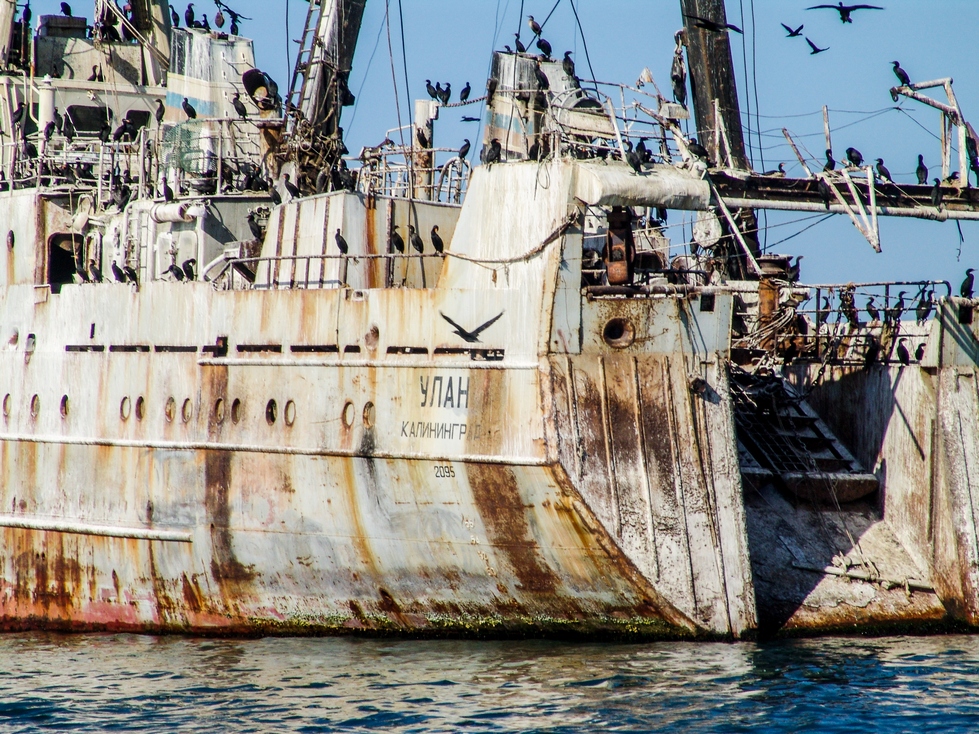
| 89. "Ulan" |
Walvis Bay harbour | Ulan, a fishing trawler, was moored for a long time off Walvis Bay harbour. It was abandoned apparently due to debts accumulated by ship's owners. Over the time it became a home to a hundred nests of the protected Cape cormorant, an important breeding site for the birds as well as an important attraction to local marine eco-tourism operators. The vessel was scrapped in January 2009, rather suddenly, with cormorant colony allegedly wiped out when an old Russian fishing vessel was towed to a scrap yard. According to Buks de Koker, spokesperson for the vessel's owner, Ulan start taking some water and it was decided that it should be scrapped to avoid sea pollution. |
|
| - | - | - | - |
|
90. Unidentified American whalers |
Conception Bay | Wrecks of unidentified American whalers can be seen at Conception Bay, masts of at least three ships. | - |
| - | - | - | - |
|
91. Unidentified Dutch wreck |
1748/ Meob Bay |
Unidentified Dutch wreck 1748 at Meob Bay | |
| - | - | - | - |
| 92. Unidentified old East India ship wreck |
Sandwich Harbour | - | - |
| - | - | - | - |
|
93. "United Trader" |
16.12.1974/ 10 miles north of Spencer Bay |
"Otavi" was stranded at Spencer Bay's beach in a small bay. This wreck can only be reached by foot or by sea. Travel northwards of Otavi one can see the detonated vessel "United Trader", a ship that ran aground in the early seventies with 700 tons of explosives on board. The vessel, with load, was detonated in 1974 with pieces of metal falling in an area of more than 5 km radius. The explosion was even felt in the Luderitz area. Travel further north to another shipwreck, the vessel "Arkona". | - |
| - | - | - | - |
| 94. "Valkyrie" |
18.10.1965/ south of Meob Bay |
- | - |
| - | - | - | - |
| 95. "Vikingur" |
21.01.1967/ 75 miles south of Walvis Bay |
- | - |
| - | - | - | - |
| 96. "Viente e Oito de Maio" |
October 1966/ just north of Toscanini |
This motor powered fishing vessel wrecked on Palgrave Point in Namibia. | - |
| - | - | - | - |
|
97. "Vipava" |
07.07.1968/ north of Swakopmund |
The MS Vipava, Iranian freighter of 630 tons, ran aground 16 miles north of Swakopmund in thick foggy conditions. It was under command of Captain Margaretic. The captain had to shut down the engines because the fuel was contaminated by sea water as she had punctured both fuel tanks. The Tug Otto Siedle arrived on the scene and tried to pull the freighter off the sandbank but the thick towing rope snapped and the crew, hungry and thirsty, decided to abandon the ship. This action most probably resulted in the total loss of the freighter, as nobody was available to affix further towropes. By Monday morning the hull had split open and water had seeped into her engine room. The vessel was carrying 220 tons of steel plates and 350 tons of paper. She was on her way to Khorramsharh in Iran. At low tide her engine blocks are visible from shore. According to another source Vipava was the Yugoslav freighter on a voyage from Yugoslavia to Iran with a cargo of steel plates, rails and paper. |
 |
| - | - | - | - |
| 97.1. "Vlissingen" |
1747/ Meob Bay |
According to Werz
(2007), the Vlissingen was a Dutch East India Company (hereafter VOC
ship) that was on its way to Table Bay from Middleburg in the then Dutch
republic. The ship was likely carrying European goods for trade in the
Far East where the Dutch had overtaken the Portuguese in controlling the
lucrative trade for Chinese porcelain, Indian spices, and other
commodities. Werz (2007) stresses that the Vlissingen was identified
based on the coinage that washed ashore in Meob Bay on the Namibian
coast. It is thought that the coins were minted around 1746 in the then
Dutch Republic. Historical significance The wrecking of this ship on the Namibian coast highlights the treacherous nature of the coast and its importance as a route for the ships that sailed from Europe to Asia. Based on the earlier contacts between indigenous people on the Namibian coast and seafarers (Kinahan 2000) there is a strong possibility that the Vlissingen might have veered close to the shore looking for trade or refreshing their ship with fresh food and water. This put the ship within an important historic period that was dominated by the Dutch in the Far East. To highlight the linkage of the Vlissingen shipwreck to the Netherlands, it was established from Mr. Von Schumann that he once benefitted from funding provided by the Dutch Embassy in Namibia. This funding enabled him to receive training in the Netherlands concerning the study of this shipwreck. What this funding indicates is that the linkage of this shipwreck to the Netherlands is well known and is appreciated by the Dutch government. It is a further indication of the potential economic significance of Vlissingen that can be derived through sustainable tourism. |
|
| - | - | - | - |
| 98. "Winston" |
17.10.1970/ Durissa Bay |
The Winston, East German trawler of 180 tons grounded in thick fog two miles south
of the Ugab River Mouth. For many years she was a well-known landmark
and cormorants used to nest on her battered frame. Eventually she could
not withstand the beating of the sea and slowly disintegrated. Some
parts of her structure were washed ashore. Parts of her engine block are
still visible today. The Winston indicates a favourite angling spot for
holidaymakers and can be seen at Durissa Bay, about 23 km north of Mile
108. According to another source
The Winston was a South African wetfish trawler built in 1961 and owned by
Agterbaai Trust.
South of the Winston there is another visible wreck, but nothing is
known of this ship.
|
|
| - | - | - | - |
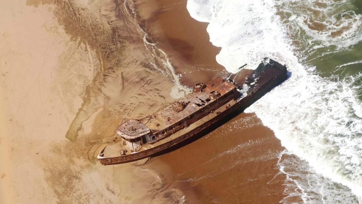
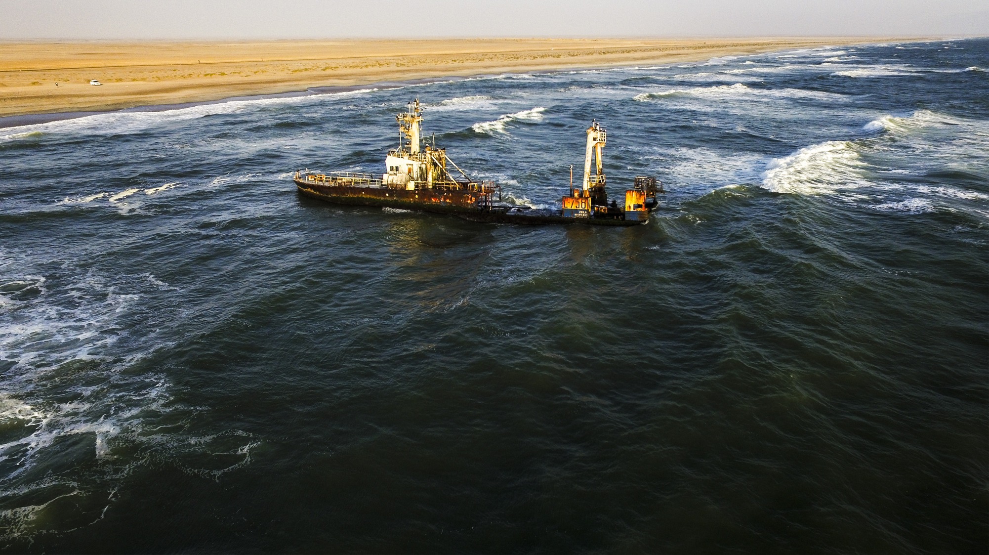
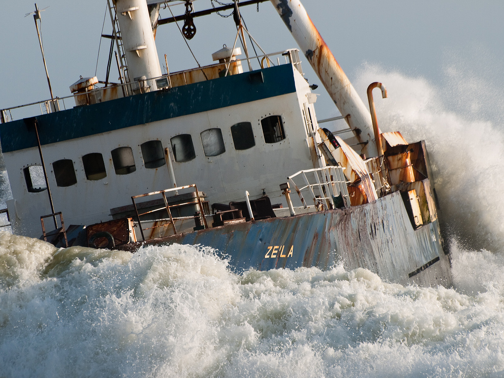
| 99. "Zeila" |
25.08.2008/ 14 km south of Henties Bay |
Video Zeila The Zeila was stranded on 25 August 2008 in the early morning hours near ôDie Walleö, a popular fishing spot about 14 km south of Henties Bay. The fishing trawler was retired by Hangana Fishing of Walvis Bay, was sold as scrap metal to an Indian company and got stranded after it came loose from its towing line while on its way to Bombay shortly after it left Walvis Bay. YouTube aerial video Zeila: As the Zeila had been stripped to its
shell it was decided to tow her to India. In August 2008 the Lara left
Walvis Bay harbour on it's way to Bombay, with the Zeila in tow. In the
middle of the night, not far beyond the Walvis Bay harbour limits, the
towing line broke and the Zeila began to drift. Two Indian crewmen, who
were at the mercy of the rough Atlantic waters, who were on board with
nothing more than a life jacket and a handheld walkie talkie. After a
terrifying night, cut off from the world and with little hope of
survival, dawn finally brought some hope. During the night the Zeila had
drifted close to shore and finally came to rest on a sandbank near a
popular fishing spot. Being a weekday, the fishing spot would normally
have been empty, but luck was on the side of the crewmen. It was a
public holiday and several fishermen had decided to make the best of the
day and go fishing. Frantically the two crewmen signalled the fishermen,
who alerted Henties Bay authorities to the plight of the two men.
In Henties Bay two well known Namibian businessmen, Quinton Liebenberg
and Archie Van der Merwe, jumped into their racing rubber duck and began
what was later to be described as a nail biting rescue. Heading through
waves at high tide, the two men made their way to the stranded Zeila.
After a struggle of close to an hour, Liebenberg and Van der Merwe
finally managed to get their rubber duck along side the stranded Zeila.
The two Indian crewmen now had to make a leap of faith from the Zeila
into the rubber duck. To the encouraging cheers from onlooking fishermen
the two jumped and landed safely in the rubber duck. Once on shore the
crew were taken to hospital and treated for shock and minor injuries.
|
|
| Unidentified & various shipwrecks | |||
| 100. "Victor N Franco" 100.1. "W McCann" |
From "Tales from the great north road the great Kaokoveld diamond raid"
(2012 African Hunter Magazine): "Plagued by vicious sandstorms, they drove south to Cape Frio where they left a fuel dump. Just south of the cape they came across the wreck of a wooden sailing ship at least a hundred yards inland from the shore. There was a deck chair with a brass plate inscribed "Victor N Franco", but whether that was the name of the ship or a passenger they never discovered. A couple hundred miles south of the Kunene they came across a stretch of coast that had been pegged by a prospector named Isaacs in 1929, but though they dug samples, they found no diamonds. Near the claim was the hatch cover of a ship that had the name "W McCann" inscribed on it. and next to it lay a skeleton. Nearby they found eleven more skeletons, and they gave them all as decent a burial as they could. Though they continued to search the coast, they never did find any gemstones - at least that is what they told the syndicate - and eventually returned to Mossamedes, and from there, Johannesburg." |
||
