Orange
River
Rivers of Namibia
The Orange River (Afrikaans/Dutch:
Oranjerivier), Gariep River, Groote River or Senqu River is the longest
river in South Africa, bordering Namibia. It rises in the Drakensberg mountains in Lesotho,
flowing westwards through South Africa to the Atlantic Ocean. The river
forms part of the international borders between South Africa and Namibia and
between South Africa and Lesotho, as well as
several provincial borders within South Africa. Although the river does not
pass through any major cities, it plays an important role in the South
African economy by providing water for irrigation in southern Namibia, as well as
source of hydroelectric
power stations. The Orange River was named by Robert Jacob Gordon after the Dutch Royal
House. Several tour operators offer
canoe trips
along the Orange River.
Aerial video:
Noordoewer & Orange River
Course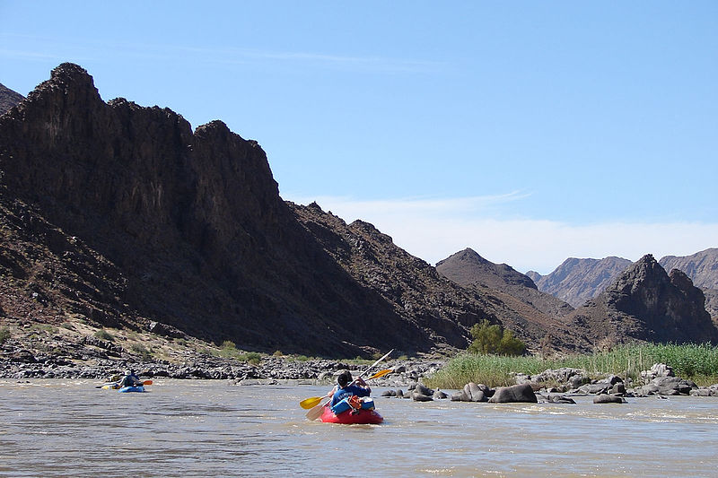 of Orange River
The Orange River rises in the Drakensberg Mountains along the border between South
Africa and Lesotho, about 190 km (120 miles) west of the Indian Ocean and at an
altitude of over 3,000 m. While in Lesotho, the river is known as the Senqu
and parts of it freeze in winter, because of the altitude there.
The river then runs westwards through South Africa, forming the
south-western boundary of the Free State province. In this section the river
flows into first the Gariep Dam (the largest in the country), and on to the
Vanderkloof Dam. From the border of Lesotho to below the Van der Kloof Dam
the river bed is deeply incised. Further downstream the land is flatter, and
the river is used extensively for irrigation.
At the western point of the Free State, southwest of Kimberley, the Orange
meets with its main tributary, the Vaal River, which itself forms much of
the northern border of the province. From here the river flows further
westwards through the arid wilderness of the southern Kalahari region and
Namaqualand in the Northern Cape Province to meet with Namibia at the 20th
degree of east longitude. From here it flows westwards for 550 km, forming
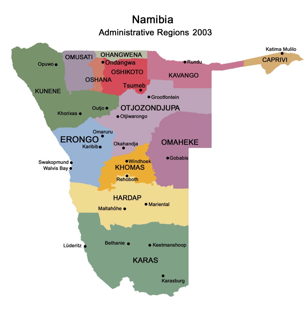
the international border between the province and Namibia's
Karas Region.
On the border, the river passes the town of Vioolsdrif, the Customs and
Excise post between South Africa and Namibia.
In the last 800 km (500 mi) of its course the Orange receives many
intermittent streams and several large wadis lead into it. In this section,
the Namib Desert terminates on the north bank of the river, so under normal
circumstances the volume of water added by these tributaries is negligible.
Here the bed of the river is once again deeply incised. The Hundred Falls or
Augrabies Falls are located on this section of the Orange, where the river
descends 122 m (400 ft) in a course of 26 km (16 mi).
This image shows only the last c. 100 kilometers of the Orange River. In
this last stretch the gravel deposits in the river bed and along the banks
are rich with diamonds, and several diamond mines operate along the stretch
pictured here.
The Orange empties into the Atlantic Ocean at Alexander Bay, which lies
about equidistant between Cape Town and Walvis Bay.
Some 33 km (21 mi) from its mouth it is completely obstructed by rapids and
sand bars and is generally not navigable for long stretches.
The river has a total length of 2,200 km (1,400 mi).
Tributaries of the Orange
River
The river starts at the border between KwaZulu-Natal and Lesotho, high in
the Drakensberg Mountains as the Senqu River. Tributaries in Lesotho
include: the Koakoatsi River, Tlhanyaku River, Moremoholo River, Mokhotlon
River, Sehonghong River, Khubelu River, Makhoaba River, Bobatsi River,
Mphelebeko River, Semena River, Nashai River, Litsoeyse River, Matebeng
River, Liboleng River, Tsoelike River, Linakeng River, Qabane River,
Kolo-La-Tsoene River, Senqunyane River, Qhoali River, Meletsunyane River,
Qhuasing River, Outing River, Sebapala River, Thaling River, Masitise River
and the Tele River (the border river between South Africa and Lesotho.
Tributaries in South Africa include: the Makhaleng River (the west border of
Lesotho), Kromspruit, Bamboesspruit, Gryskopspruit, Winnaarspruit,
Knoffelspruit, Wilgespruit, Nuwejaarspruit, Kraai River, Melkspruit,
Sanddrifspruit, Stormbergspruit, Moddelbulspruit, Palmietspruit, Caledon
River, Oudagspruit, Broekspruit, Bossiespruit, Brakspruit, Suurbergspruit,
Donkerpoortspruit, Oorlogspoort River, Rietkuilspruit,
Vanderwaltsfonteinspruit, Otterspoortspruit, Paaiskloofspruit, Seekoei
River, Kattegatspruit, Knapsak River, Hondeblaf River, Berg River,
Lemoenspruit, Vaal River, Withoekskloof, Lanyonspruit, Diep River, Brak
River, Karabeeloop River, Prieska River, Rooiloop River, Kat River, Marydale
River, Soutloop River, Elmboog Sloot, Eselfontein River, Matjies River,
Donkerhoekspruit, Helbrandkloofspruit, Hartbeer River, Slang River, Brabees
River, Molopo River, Bul River, Kourop River, Bak River, Kraalputs de Loop,
Narrie se Loop, Samoep River, Kaboep River, Mik River, Hartbees River, Brak
River, Matjies River, Groen River, Kahams River. Tributaries in Namibia
include: the Kleinap River, Ham River, Udabis River, Velloor River, Sambok
River, Eendoorn River, Girtus River, Hom River, Davignab River, Haib River,
Sambok River, Gamkap River.
Catchment and rainfall
In the dry winter months the volume of the water in the river is
considerably reduced because of the rapid run-off and evaporation. At the
source of the Orange the rainfall is approximately 2,000 mm per annum but
precipitation decreases as the river flows westward; at its mouth the
rainfall is less than 50 mm per annum. The factors that support evaporation,
on the other hand, tend to increase in a westerly direction. However, in the
wet season (summer) the Orange river becomes an impetuous, brown torrent.
The huge mass of sediment carried constitutes a long-term threat to all
engineering projects on the river.
The total catchment of the Orange River (including the Vaal) extends over
973,000 km², i.e. equivalent to about 77% of the land area of South Africa
(1,268,5358 km²). Approximately 366,000 km² (38%), however, is situated
outside the country in Lesotho, Botswana and Namibia.
History
Name of the Orange River
The earliest pre-colonial inhabitants called the river Gariep'. The river
was named the Orange River by Colonel Robert Gordon, commander of the Dutch
East India Company garrison at Cape Town, on a trip to the interior in
1779. Gordon named the river in honour of William V of Orange. A popular
but incorrect belief is that the river was named after the supposedly orange
colour of its water, as opposed to the colour its tributary, the Vaal River
( 'vaal' being Afrikaans for pale or grey). Since the end of apartheid, the
name "Gariep" has had greater favour in official correspondence in South
Africa, although the name "Orange" has greater international recognition. In
Lesotho, where the river rises, it is known as the Senqu River.
Economy
As the collection point for the majority of South Africa's water, the Orange
River plays a major role in supporting agriculture, industry and mining. To
assist in this, two large water schemes have been created, the Orange River
Project and the Lesotho Highlands Water Project. Historically, the river
played an important role in the South African diamond rush, with the first
diamonds in the country being discovered in alluvial deposits on the Orange.
Today, several commercial diamond mines operate along the final stretch of
the Orange River and around its mouth. Finally, because of the lack of
dangerous animals and high water levels during summer, the river is used for
recreational canoeing and rafting.
Orange River Project
The Orange River Project (ORP) was one of the largest and most imaginative
projects of its kind in South Africa. It was constructed by Hendrik
Verwoerd's government at the height of the apartheid era. The ORP was built
to utilise the unused water of the Orange River - which, without the Vaal
River, represents some 14.1% of the total runoff in South Africa - and in
the process, to satisfy an increasing demand for water. The main objectives
of the project were:
to stabilise river flow,
the generation and transmission of hydro-electric power,
to provide a reliable water supply for users in the Orange river basin, and
to give a new lease of life to water-deficient areas in the Eastern Cape
such as the Great Fish and Sundays River valleys.
The Gariep Dam near Colesberg, named the Hendrik Verwoerd Dam when built, is
the main storage structure within the Orange River. From here the water is
supplied in two directions: westward along the Orange River (via
hydro-electric power generators) to the Vanderkloof Dam which was previously
named the PK le Roux Dam , and southward through the Orange-Fish Tunnel to
the Eastern Cape.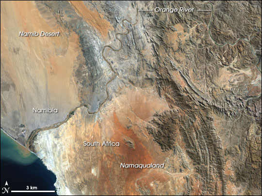
Hydro-electricity
Eskom operates hydro-electric power-stations at both the Gariep Dam and the
Vanderkloof Dam. The hydro-electric power station at the Vanderkloof Dam was
the first power-generation station in South Africa situated entirely
underground. The towns Oviston and Oranjekrag were established to facilitate
the construction and operation of the new infrastructure.
Irrigation
Irrigation in the vast area downstream of the Vanderkloof Dam, which has
turned thousands of hectares of arid veld into highly productive
agricultural land, was made possible by the construction of the Gariep Dam
and the Vanderkloof Dam. Old, established irrigation schemes such as those
at Buchuberg, Upington, Kakamas and Vioolsdrif have also benefitted because
regulation of the flow is now possible.
In recent years the wine producing areas along the Orange River have also
grown in importance.
Irrigation in the Eastern Cape has also received a tremendous boost, not
only from the additional water that is being made available but also owing
to improvement in water quality. Without this improvement the citrus farmers
along the Lower Sundays River would almost certainly have continued to
suffer losses of productivity.
Lesotho Highlands Water
Project
The Lesotho Highlands Water Project was conceived to supplement the water
supply in the Vaal River System. Water is delivered to South Africa by means
of the Delivery Tunnel which passes under the Lesotho South Africa border at
the Caledon River and then under the Little Caledon River south of Clarens
in the Free State and discharges into the Ash River about 30 km further to
the north. The scheme became viable when water demands in Gauteng reached
levels that could no longer be supported economically by alternative schemes
such as the Tugela River-Vaal River pumped storage scheme, which utilized
the Sterkfontein Dam, located near Harrismith in the Free State.
Alluvial diamonds
In 1867, the first diamond discovered in South Africa, the Eureka Diamond,
was found near Hopetown on the Orange River. Two years later, a much larger
diamond known as the Star of South Africa was found in the same area,
causing a diamond rush. This was soon eclipsed by the diamond rush to mine
diamonds directly from kimberlite at Kimberley in 1871, although alluvial
diamonds continued to be found in the Orange. Today, several commercial
diamond mines operate on the last stretch of the river, as well as the
beaches around its mouth. Diamond mines also operate on the middle stretch
of the river.
Rafting and
canoeing
During the temperate months of March and
April, given good rains and the sluices of the dams being open a canoeist
(or rafter) can easily travel 30 km per day. The lower reaches of the river
are most popular, because of the spectacular topography. Commercial tours
are available and these expeditions depart from the border town of
Vioolsdrif.
Miscellaneous -
crocodiles
Because of the river's geographical location, it is too cold in winter to
support crocodiles.
Maps
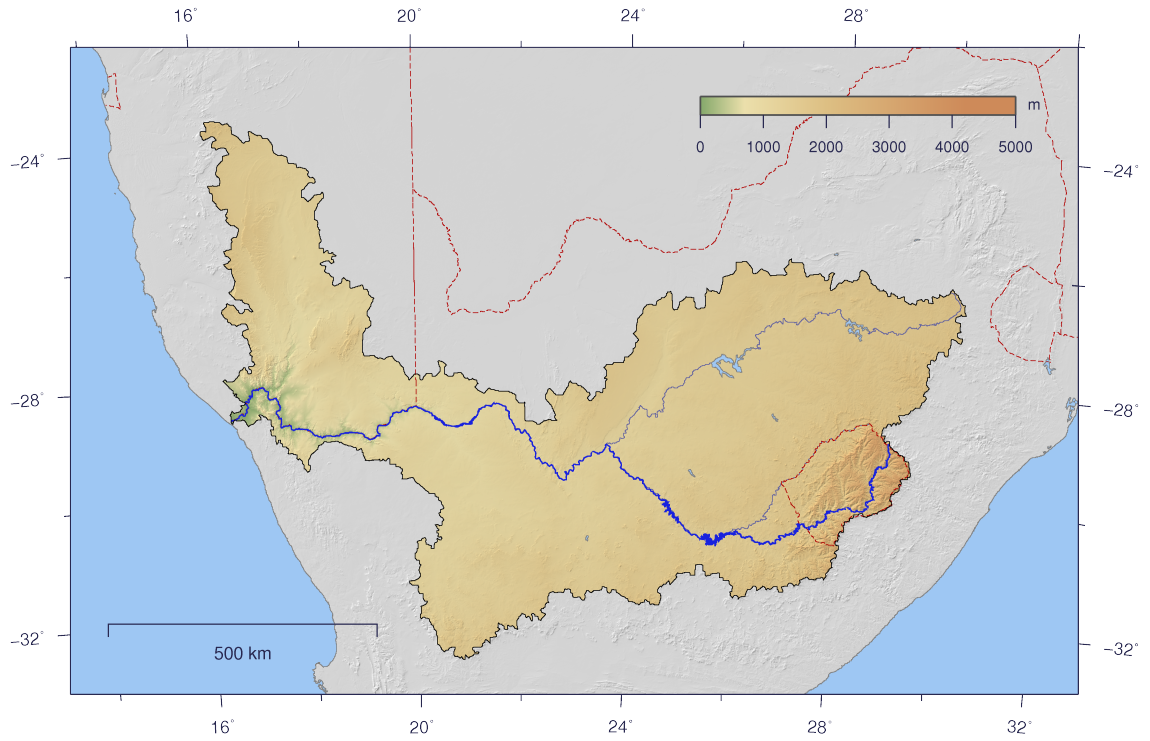
The course and watershed of the Orange
River. This map shows a conservative border for the watershed. Specifically,
the Kalahari basin is excluded, as some sources say it is endorheic. Some
other sources using computational methods show a basin which includes parts
of Botswana (and hence of the Kalahari).
@
Orange River Mouth
@ Amanzi River Camp - canoeing and river trips
Facebook:
NAMIBIA:
https://www.facebook.com/groups/namibia.namibia
TRAVEL NAMIBIA:
https://www.facebook.com/groups/travelnamibia
KEETMANSHOOP:
https://www.facebook.com/groups/keetmanshoop.namibia
DRONESBERG AERIAL PHOTO/VIDEO:
https://www.facebook.com/dronesberg
Contact & information:
E-mail:
info@namibweb.com
Reservations are only accepted in writing: by fax or via e-mail.
Final availability confirmation: in writing: by fax or via e-mail.
Terms & conditions,
Payment options and
Cancellation policy


Page created and serviced by

www.namibweb.com
Copyright © 1998-2025
namibweb.com - The online guide
to Namibia
All rights reserved |
JOIN
|
VIDEO PORTFOLIO
|
VIDEO/PHOTO COLLECTION
Telegram
| YouTube |
Blog
Page is sponsored by ETS &
Exploring Namibia TV
Disclaimer: no matter how often this page is updated and its accuracy is checked,
www.namibweb.com and ETS
will not be held
responsible for any change in opinion, information, facilities, services,
conditions, etc. offered by
establishment/operator/service/information provider or any third party