KUNENE REGION
OPUWO District
ARBORETUM
Unpublished, surveyed 1994 (Martini & Marais)
BLISTER POT
Surveyed (SASA Bull 31: 25-41).
BVWQ GAT
Surveyed, no pools (SASA Bull 31: 25-41). Alias Beesvlakte-Warmquelle pot.
COLUMBARIUM SINK
Unpublished, surveyed 1994 (Martini & Marais)
HERMITAGE
Unpublished, surveyed 1994 (Martini & Marais)
MONEY BOX POT
Unpublished, surveyed 1995 (Irish, Marais, and Martini)
ORUMANA
Surveyed (SASA Bull 31: 25-41)
ORUPOKO NDUVAKA OZONGOMBE
Unpublished, surveyed 1995 (Irish, Marais, and Martini).
ORUPOKO OMUMBUYU I & II
Unpublished, surveyed 1995 (Irish, Marais, and Martini).
ORUPOKO OMUMBUYU III
Unpublished, surveyed 1995 (Irish, Marais, and Martini).
ORUPOKO RONDJOU
Unpublished, surveyed 1995 (Irish, Marais, and Martini).
PARAKIETGAT
Surveyed (SASA Bull 31: 25-41)
TRAVERTINE
Unsurveyed rock shelter (J. SWA Sci Soc 34/35: 43-45)
WACKDOOM ABYSS
Unpublished, surveyed 1994 (Martini & Marais). At 120 m vertical the deepest
pitch in Namibia.
KHORIXAS District
BRAUNFELS I & II
Unpublished, surveyed 1994 (Martini & Marais)
BRAUNFELS RESERVOIR
Unsurveyed, location known.
TEMPLE OF DOOM
Surveyed 1994, intersect ground-water (Karstologia)
TWYFELFONTEIN WONDERGAT
Surveyed, intersect ground-water (Hohlenverein 3 ; SASA Bull. 27:
53-99; SASA Bull 31: 25-41)
VERSPOT (John's cave)
Surveyed (SASA Bull 27: 80). Etymological note: verspot = ridiculous.
OUTJO District
ACHAWACHAB
Relocated by Brain, Loftie, Venske & Burger in 1994 from data in Marais &
Irish (Madoqua). Surveyed 1995 (Irish, Marais and Martini). (Jaeger 1920: 14; Hohlenverein
6/7: 6).
AIKAB HEMICENOTE
Surveyed, intersect ground-water (Madoqua). With a surface area around 0.9
ha the second largest underground lake in Namibia.
DEENSGROT
Surveyed (SASA Bull 32: 48-71)
GAMKARAB
Unpublished, surveyed 1992, intersect ground-water (Marais)
GUMSES
Unsurveyed, location known
/KHARUB AS
Surveyed (SASA Bull 32: 48-71)
LEEURANTE
Surveyed (SASA Bull 32: 48-71)
MOOIHOEK
Surveyed (SASA Bull. 27: 53-99)
MUNSTERLAND
Surveyed (SASA Bull. 27: 53-99)
/NERAB AS
Surveyed (SASA Bull 32: 48-71)
OTGROT
Surveyed (SASA Bull 31: 25-41)
RAYMOND SE GATE
Cavities in calcrete, one surveyed (Madoqua)
TSAWISIS
Unsurveyed, location unknown (Mitt SWA Wiss Ges V/3 Marz 1964)
TSUMASA
Surveyed (Madoqua)
UNSUSIB
Location unknown (Jaeger 1920)
VREDEKOPPIES
Unsurveyed, location known (Madoqua)
OTJOZONDJUPA REGION
TSUMKWE District
GAM
Surveyed (SASA Bull. 31: 93-95). Cave 2 re-surveyed 1995 (Martini &
Marais)
GROOTFONTEIN District
AASENHEIM
Unsurveyed, location unknown (Mitt. SWA Wiss. Ges. XVIII?10-11 Jan/Feb 1978)
AIGAMAS
Access restricted. Home of the cave catfish Clarias cavernicola. Surveyed,
intersect ground-water (Hohlenverein 5; SASA Bull. 27: 53-99; J. Nam Sci
Soc 42: 75-83)
ALBATHOHLE
Unsurveyed, location unknown (Proc. 6 Simp. Spel.: 104).
AUROS BUSH CANYON
Surveyed (Otavi '95)
AUROS LEOPARDENHOHLE
Surveyed (Otavi '95)
AUROS SCHWINDE
Surveyed (Otavi '95)
EINBRUCH II
Unsurveyed, location unknown (Mitt. SWA Wiss. Ges. XVIII/10-11, Jan/Feb
1978)
EINBRUCHSHOHLE
Unsurveyed, location unknown (Mitt. SWA Wiss. Ges. Dec74/Jan75)
FELSENMEERSCHACHT
Unsurveyed, location unknown (Mitt. SWA Wiss. Ges. Dec74/Jan75)
FORCHTENBERGER
Unsurveyed, location unknown (Mitt. SWA Wiss. Ges. Dec74/Jan75)
GIPFELSCHACHT
Surveyed (Otavi '95)
GROTTA FERRARIS
Unsurveyed, location unknown (Mitt. SWA Wiss. Ges. XVIII?10-11 Jan/Feb 1978)
HAMBURGER ABSTEIG
Unsurveyed, location unknown (Mitt. SWA Wiss. Ges. Dec74/Jan75)
HIGHLANDSPOT
Unsurveyed, location unknown (Mitt. SWA Wiss. Ges. Dec74/Jan75)
HOHLE OHNE NAME
Unsurveyed, location unknown (Mitt. SWA Wiss. Ges. XVIII?10-11 Jan/Feb 1978)
JOHANNSGROT
Partly surveyed (Otavi '95; Sketch map SASA Bull. 29: 1-4)
KEMPTEN II & III
Unsurveyed, location unknown (Mitt. SWA Wiss. Ges. Dec74/Jan75)
KEMPTENHOHLE
Surveyed (SASA Bull 32: 48-71)
KIMBERLITE CAVE
Unpublished, surveyed 1995 (Martini & Marais)
KING
Unsurveyed, location unknown (Mitt. SWA Wiss. Ges. XVIII?10-11 Jan/Feb 1978)
KOMUKANTI
Unsurveyed, location unknown (Afrikanische Heimatkalender 1941: 38)
LUDWIG SE GROT
Unpublished, surveyed 1995 (Martini & Marais)
MAMBASCHACHT
Unsurveyed, location unknown (Mitt. SWA Wiss. Ges. XVIII?10-11 Jan/Feb 1978)
MARBLE SINK
Surveyed (SASA Bull 32: 48-71)
MARCHENHOHLE
Surveyed (SASA Bull 32: 48-71)
OBAB
Unpublished, surveyed 1994-5, intersect ground-water (Martini & Marais)
OTAVIBLICK
Unsurveyed, location unknown (Mitt. SWA Wiss. Ges. XVIII/10-11, Jan/Feb
1978)
PORTAL
Unsurveyed, location unknown (Mitt. SWA Wiss. Ges. Dec74/Jan75)
PSEUDO-KEMPTEN
Surveyed (SASA Bull 32: 48-71)
RHIZINUS
Unsurveyed, location unknown (Mitt. SWA Wiss. Ges. Dec74/Jan75)
SCHOKOLADEN
Unsurveyed, location unknown (Mitt. SWA Wiss. Ges. XVIII/10-11, Jan/Feb
1978)
SCHRAGE SPALTE
Unsurveyed, location unknown (Mitt. SWA Wiss. Ges. XVIII?10-11 Jan/Feb 1978)
SCHWEISSLOCH CAVES
I & II surveyed (SASA Bull. 27: 53-99)
TERRYSRUST
Unsurveyed, location unknown (Mitt. SWA Wiss. Ges. XVIII?10-11 Jan/Feb 1978)
TOTESTAL
Partly surveyed (SASA Bull 32: 48-71)
UHLENHORST-UHLMANNHOHLE
Surveyed (SASA Bull 32: 48-71)
UISIB I
Unpublished, surveyed 1995 (Martini & Marais)
UISIB II
Unpublished, surveyed 1995 (Martini & Marais)
UISIB III
Unpublished, surveyed 1995 (Martini & Marais)
WOHNHOHLE
Unsurveyed, location unknown (Mitt. SWA Wiss. Ges. Dec74/Jan75)
OSHIKOTO REGION
TSUMEB District
BRECCIA
Unsurveyed, location unknown (SASA Bull. 1968)
COETZEE'S BAT CAVERN
Unsurveyed, location unsure
DANTE
Unpublished, surveyed 1988 (Irish & Marais)
DRAGON'S BREATH
Surveyed & published. Discovered in 1986, originally described as
"Drachenhauchloch", and reportedly the largest known cave lake (SASA Bull.
27: 53-99; Spelunca 38: 24-29; SASA Bull. 30: 11-26; SASA Bull. 33:
83-87)
GANACHAAMS
Unsurveyed, location unknown, declared national monument, also named Glittering
Falls (SASA Bull. 1968)
GHAUB
Registered as a national monument. One of the earliest described caves in Namibia
and presently with the third longest total passage length, sometimes written as GAUB.
(Jaeger 1920; SASA Bull. 1969; SASA Bull. 27: 53-99; Spelunca 38:
24-29; SASA Bull. 29: 4-5).
GUINAS LAKE
Surveyed cenote (SASA Bull. 29: 6-10), and a well known location for deep
diving (SASA Bull. 29: 12-14). It is home to an endemic fish Tilapia guinasana
(J. Nam Sci Soc 42: 75-83). Though the larger of the two open karst lakes, it is
still significantly smaller than the Aikab and Dragon's Breath cave lakes.
HARASIB
Surveyed, intersect ground-water. Together with known water depth the deepest
recorded cave in Namibia (Sketch map SASA Bull. 1968; )
HELLWEGHOHLE
Surveyed (SASA Bull. 27: 53-99)
KLEIN NOSIB
Surveyed, intersect ground-water (SASA Bull 32: 48-71). Also recorded as
Hawusib or Hawuseb.
KLEINE ANFANGE
Surveyed (SASA Bull. 27: 53-99). Originally called Little Beginnings, since
Dragonsbreath was discovered during a survey visit to this cave.
LEOPARDENBERGHOHLE
Unsurveyed, intersect ground-water (Jaeger 1920). Also recorded as Harasib IV.
NOSIBHOHLE
Partly surveyed (Rohrbach 1907; Hohlenverein 3; Otavi '95)
OTJIKOTO LAKE
Unsurveyed cenote, and an underwater national monument. Divers can obtain permits
to view WW1 artillery and other war materials discarded by German troops into the cenote
before surrendering in 1915. Some of the weaponry was retrieved in the late 1960's, and
are on display at the Tsumeb Museum and the Alte Feste in Windhoek.
PIETSGAT
Surveyed (Otavi '95)
POFADDERGAT
Surveyed, with the second longest total passage length in Namibia, intersect
ground-water (Spelunca 38: 24-29; SASA Bull 32: 48-71)
RAMA GUANO
Unsurveyed, location unknown (SASA Bull. 1968)
RAMA
Unsurveyed, location unknown (SASA Bull. 1968)
SCHLECHTER'S SCHLUCHT I
Surveyed (Otavi '95)
SCHLECHTER'S SCHLUCHT II
Surveyed (Otavi '95)
SCORPION MAZE EXTENSION
Surveyed (Otavi '95)
SCORPION MAZE
Surveyed (Otavi '95)
SHIVUTE'S PAVIANHOHLE
Surveyed (Otavi '95)
TAUFBECKENGROTTE
Surveyed (Otavi '95)
TIGERHOHLE
Unsurveyed, historically well known cave (Hohlenverein 6/7: 4)
WINDGAT
Partly surveyed 1994 (Otavi '95)
ERONGO REGION
KARIBIB District
HONEB AS
Surveyed (Hohlenverein 4; SASA Bull.)
NOOITGEDACHT
Surveyed (Hohlenverein 4; SASA Bull 32: 48-71)
NOOITGEDACHT 3 & 4
Unpublished, surveyed 1993-1995 (Hohlenverein 4; Martini, Marais, Irish)
SWAKOPMUND District
GIFGAT (Batshole)
Surveyed (Irish, Martini & Marais, Madoqua in press)
GIFGAT 2
Surveyed (Irish, Martini & Marais, Madoqua in press)
HUSAB
Surveyed (Hohlenverein 3 ; Irish, Martini & Marais, Madoqua in
press). Also known as Falschen Heinrich.
ROSSING-WES
Surveyed (Hohlenverein 9: 17). Re-surveyed 1995 (Irish,
Martini & Marais, Madoqua in press)
KHOMAS REGION
WINDHOEK District
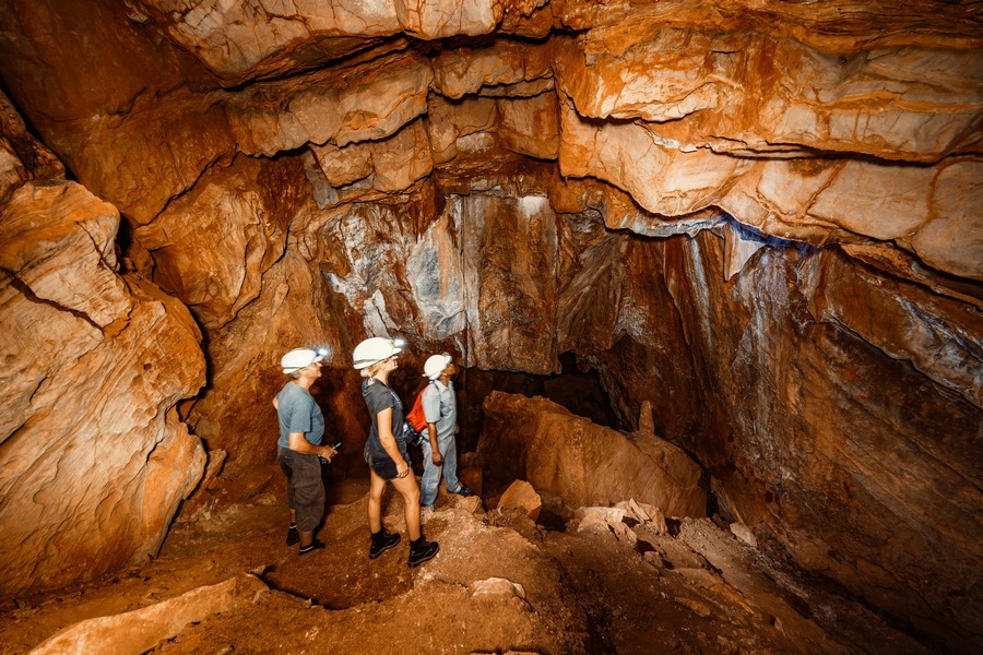
ARNHEM
The longest cave in Namibia, with slightly over 4800 m total passage length,
intersect ground-water (Spelunca 38: 24-29). The cave at one stage contained very
large deposits of bat guano, which has been extracted on a large scale. It is presently the
only tourist cave in Namibia. Its marketing as a tourist attraction is unusual, as the
cave is very dusty and dry, with almost no secondary cave formations. It is advertised as
an underground trail, and visitors are only allowed torches or cave lamps to negotiate
Arnhem's large chambers and winding passages. Visitors therefore experience a genuine cave
ambience, leavened with unexpected evidence of human endeavour left behind by guano
miners. The minimal development causes minimal disturbance of the extensive and diverse
bat population, which also ensures the conservation of several unique invertebrate
species. Most visitors prefer a guided tour, though the trail was
designed to allow self-guided visits. Overnight accommodation is available at the site.
BIH
Surveyed (SASA Bull.). Alias Beer In Hand.
GAUAB AS
Surveyed (Karstologia; SASA Bull.)
NAOS
Unpublished, surveyed 1988-1989, intersect ground-water (Irish & Marais)
HARDAP REGION
MALTAHOHE District
KOPSJOPGROT
Deep overhang, sketch map
MARCKERHOHLE
Surveyed (Cimbebasia 13: 69-74)
NEURAS _HOAB
Surveyed 1995 (Irish, Martini & Marais, Madoqua in press)
VALLEGROT
Surveyed (SASA Bull 27: 100)
KARAS REGION
LUDERITZ District
BOGENFELS CAVE SWARM
Unpublished, surveyed 1994 (Irish & Marais) (Kaiser, Die Diamantkuste SWA's)
EBERLANZHOHLE
Unsurveyed rock shelter, tourist attraction.
GROTTEN INSEL
Unpublished, surveyed 1994 (Irish & Marais) (Kaiser, Die Diamantkuste SWA's)
TORBOGEN BUCHT
Unpublished, surveyed 1994 (Irish & Marais) (Kaiser, Die Diamantkuste SWA's)
WOLWEGROT
Surveyed (SASA Bull. 27: 100)
BETHANIE District
GAMKAB
Unsurveyed deep rockshelter, location known.
MARA
Unsurveyed, location known.
Contact & information:
E-mail:
info@namibweb.com
Related: Guide for cave visitor, History of caves in Namibia
![]()
![]()
![]()
Page created and serviced by
![]()
www.namibweb.com
Copyright ę 1998-2025
namibweb.com - The online guide
to Namibia
All rights reserved |
JOIN
|
VIDEO PORTFOLIO
|
VIDEO/PHOTO COLLECTION
Telegram
| YouTube |
Blog
Page is sponsored by ETS &
Exploring Namibia TV
Disclaimer: no matter how often this page is updated and its accuracy is checked,
www.namibweb.com and ETS
will not be held
responsible for any change in opinion, information, facilities, services,
conditions, etc. offered by
establishment/operator/service/information provider or any third party
Source reference: John Irish & Eugene Marais. Namibian cave register.