Keetmanshoop
(Afrikaans: Keetman's hope) is a city in
Karas Region in southern Namibia, lying on the
Trans-Namib Railway from Windhoek to Upington in South Africa. It is named
after Johann Keetman, a German industrialist and founder of the city.
The town is situated in a semi-arid area, normally receiving an annual
average rainfall of only 152 millimetres (6.0 in), although in the 2010/2011
rainy season 254 millimetres were measured.
YouTube video of
Top 5 attractions of Keetmanshoop, Namibia:
Before the colonial era, the settlement was known as |Nu|goaes or
Swartmodder, both of which means "Black Marsh" and indicated the presence of
a spring in the area. The first white settler, Guilliam Visagie, arrived
here in 1785. In 1860 the Rhenish Missionary Society founded a mission
there to christianize the local Nama. The first missionary, Johann Georg
Schröder, arrived in Keetmanshoop on April 14, 1866, which is now marked as
the founding date of Keetmanshoop. The mission station was named after the
German trader Johann Keetman who supported the mission financially, but
never actually visited the place himself.
Geography
Climate
Keetmanshoop has a desert climate (BWh, according to the Köppen climate
classification), with hot summers and mild winters. The average annual
precipitation is 147 mm.
Notable buildings and structures
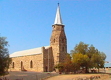
The Keetmanshoop Museum is located in the Rhenish Mission Church, a building
dating back to 1895. The church was declared an historic monument in 1978
and is a well-known landmark. Its unique combination of Gothic architecture
cast in African stone makes it one of the architectural masterpieces in the
country and a popular tourist attraction. Other notable buildings are the
post office, dating from 1910, and the railway station building.
The town is situated near two quiver tree forests, one of them being a
national monument and a major tourist attraction of Namibia. Also close to
Keetmanshoop is the Naute Dam and newly inaugurated
Neckartal Dam.
J. Stephanus Stadium is located in Keetmanshoop and is home to Fedics United
F.C., a football team in the Namibia Premier League.
Keetmanshoop is also an important center of the Karakul sheep farming
community.
Politics
Local authority results, 2010
In the 2010 local authority election, a total of 3,156 votes were cast in
the city. SWAPO won with approximately 48% of the vote. Of the three other
parties seeking votes in the election, RDP received approximately 35% of the
vote, followed by the Democratic Party (10%) and the Democratic Turnhalle
Alliance (7%).
Coordinates: 26°34'43"S 18°8'0"E
Country: Namibia
Region:
Karas Region
Constituency: Keetmanshoop Urban
Established: 14 April 1866
Population (2001):
• Total 15,778
Time zone: South African Standard Time (UTC+1)
Town Keetmanshoop is
located 495 km south of Windhoek, the capital of the country. The town is
one of the oldest in Namibia and effectively is a capital of the south. The
original settlement named Modderfontein dates back to the early 19th
century and was established due to presence of fresh water springs. In 1800s
Keetmanshoop was both a mission station and a trading post. A fort was
established in town in 1894 following the arrival of German settlers. Many
soldiers settled in the area buying farms which lead to Keetmanshoop being a
centre supporting local farming community. The railway line to Keetmanshoop
and further to Luderitz was completed in 1908.
 buildings and structures